
17 November 2014
Day 20. Waiwhui Valley to Moir Hill Reserve (TA km 517.5).


After 2 1/2 hours I finished the track and arrived at the wonderful Top of the Dome Cafe at 1245. After taking off my muddy shoes and changing into dry trousers I settled down to orange juice and the full breakfast which was big and went down quickly. I sat with a guy from Wellington who is section hiking Te Araroa Trail. He aims to be finished in 4 years. Section hiking is where you do bits of the trail spread over time. It is a way for those who can’t get 4 to 5 months off to do the trail to complete it. He had attempted the next leg through the forest (he did not know about restricted time zone). He said he had to turn back because the logging was impossible to get through and there were no markers and he couldn’t find the trail. Hmmm. The lady working at the cafe said he was not the first. I ordered a coffee and then later a post lunch slice, tea and just before I left a big soup. It was nice being warm, dry and well feed looking out at the driving rain. At around 1445 3 more hikers arrived. they were Rebecca, Graham (not sure if this is the right name) and Nicolas. I recognised Rebecca from her blog. She is raising money for Oxfam and is the most active I have seen in doing the fundraising. They were going to spend the night at Sheepworld 2 km down the road and bypass the forest section the next day. It was nice talking about the trail and good to see some kiwis doing TA as we are in the minority.
I started getting ready and left at 1630. By this time the weather had cleared which was fantastic. I felt really full after everything I had eaten but rather than slow me down my body must have stayed converting the food to energy as I felt great and powered up the steep road. The road then changed to the perfect forestry road that was nice and soft on my feet.

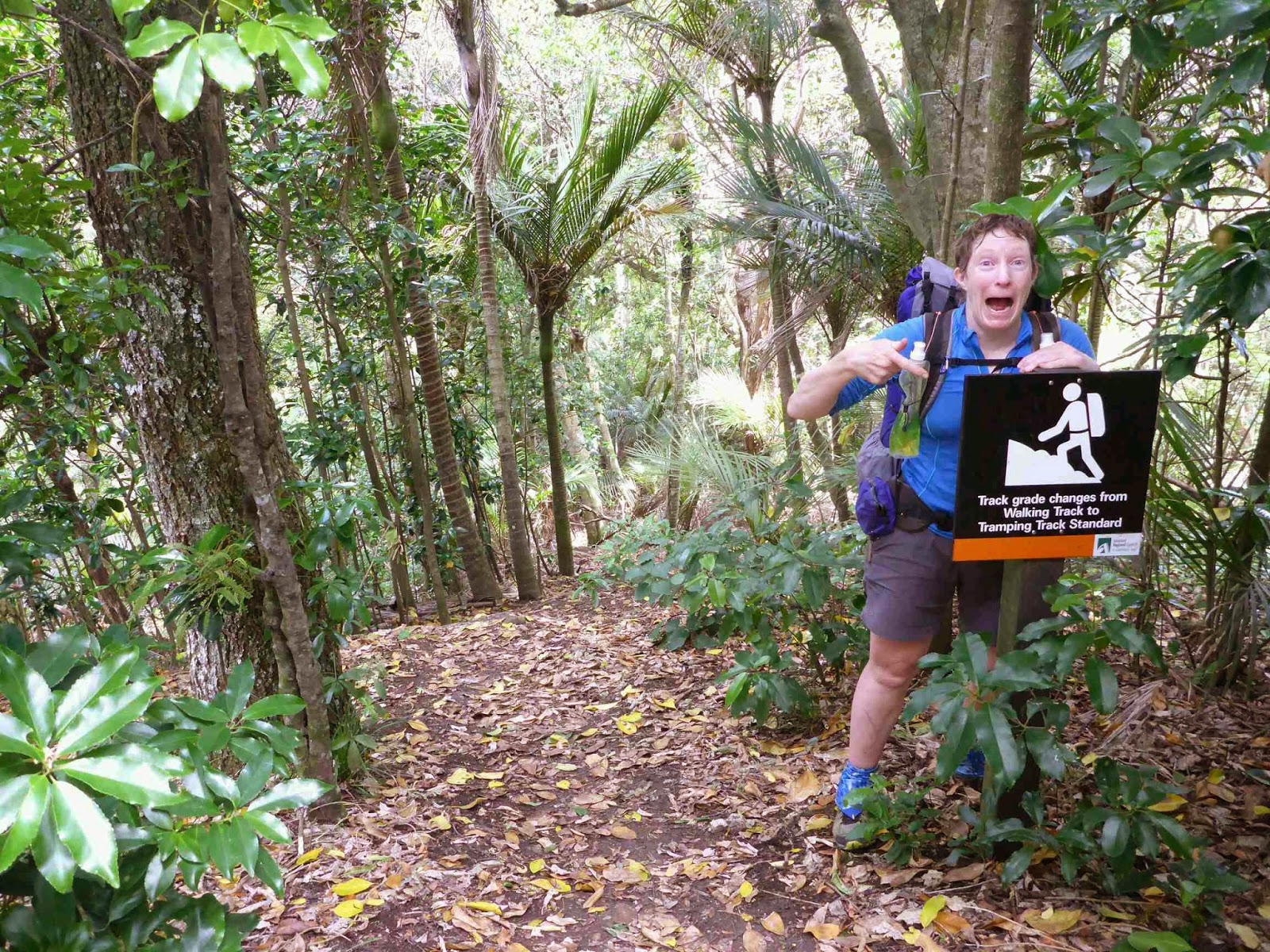
The junctions were all marked and I quickly arrived at the place where the trail narrowed.


Shortly after there was a danger tape across the track and I figured this was the start of the logging. I went around a few corners and the logging zone was reached. Here is a pictorial of what comes next.


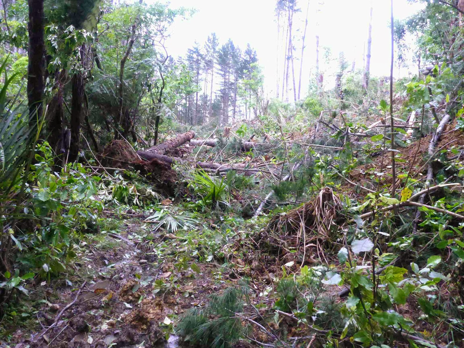

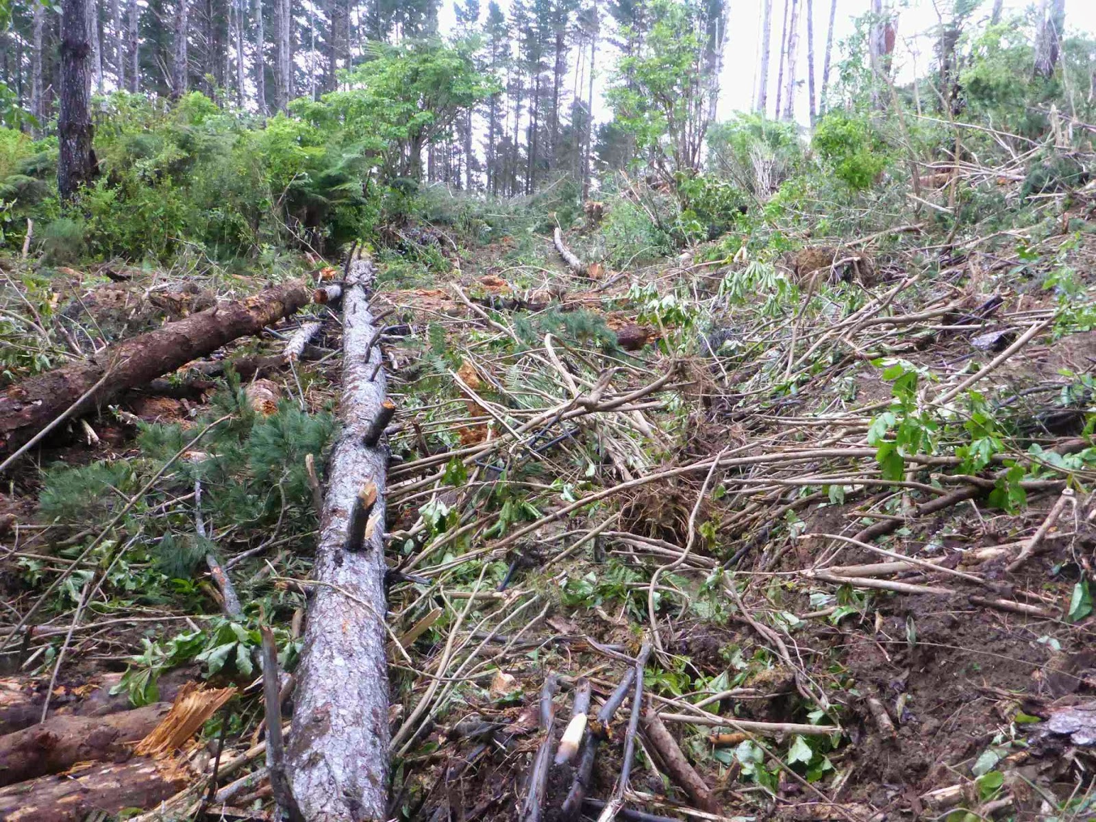


I was able to use some of the fallen trees as bridges across the debris. The trail notes said cross westwards to the DOC track which didn’t make sense. I looked in that direction and in the more logical East direction for markers but couldn’t see anything in the destruction. Straight ahead was bulldozer tracks which looked easier travel than scrambling over the logs and branches. After 40 meters I got to the brow of the hill and looked down at a gravel road. After a couple of easy scrambles over debris I followed the bulldozer tracks the last 100 meters to the road. The whole time to cross the logging area would not have been much over 5 minutes. I ended up coming into Smyth Road a few hundred metres higher than the official track did as after turning left and staying down the road I saw the proper track come out. I think the proper route should be as you enter the logging area keep following the edge around to the left and you should see the track again. On the other hand I am not sure how hard it is to go around the edge and the route I took was quick and easy.
As I headed down Smyth Road it stated raining again but this only lasted 15 minutes. From the bottom it was a short right then left and onto a quiet sealed road. Along there I met a man and girl walking their dog. The girl had a push scooter and she came racing up to me and proceeded to talk non stop except for breaks to pepper me with questions, she was entertaining- in a short dose. She also was insistent I went to their house but I could see the man was not keen so I kept telling her I had to keep going. I walked with them for nearly a km with the girl taking nonstop before saying goodbye and continuing. By this time I was too hot again so off came the jacket.
It was a further 4 km of road walking to the forest where I intended to make camp. Only one problem. Someone cut down all the trees!


As it was so windy and I thought it was going to rain again I wanted to make camp in trees. I decided to keep walking until I found somewhere to camp – sound familiar? On and on I went with no campspot. To steep or too wet. The sun went down and still nowhere. From a distance I would spot a promising site but up close nothing suitable. For the second night in a row I thought how handy a hammock would be in this situation. It was nearly dark and the wind was really strong now so I decided to camp by the road when I found a wider part with flattish non swamp verges. I got the first two pegs in, just, but could not get any more in as the ground was to hard. I was using my narrow pegs but it was not working and then a really strong wind gust yanked one of the pegs out and my groundsheet went flying away. I was working by torchlight by this stage and focused on gettng my tent packed up and getting it safely into my pack. I then had a look around for the groundsheet but I think it was half way to Cape Reinga by that stage. Also it had started raining again!
I decided to keep on walking until I found something. I could see a house light in the distance and thought about knocking on their door but the house was a long way off. I then saw a DOC sign for the Moir Reserve so I turned down and was into the shelter of the bush. I walked 5 minutes along the track, passing lots of glow worms on the banks before finding a campsite. I quickly set up and was warm and toasty in my wonderful tent.


On reviewing my maps I realised this wasn’t the trail but I decided to leave that for the morning and went to sleep soothed by the sound of the trees being battered by strong winds, rain hammering on my tent, rustling of mysterious things going about their nightly business and one Morepork calling out. Life is good.
18 November 2014
Day 21. Moir Hill to Stillwater.


Near the bottom there was long grass and my shoes got soaked from the water sitting on the grass but it was fun and the views lovely. It was then less than a km on the road to a Swingbridge and the Puhoi track. This was a fantastic 5 star walking trail (Thanks to the Steve Tindal Foundation. He is the founder of The Warehouse chain). I thought this couldn’t last the whole 5 km but it did making for a fast and enjoyable walk.


The one thing I couldn’t work out is what the numbered markers meant. There were 12 orange triangles with sequential numbers. They did not seem to be distance markets because 5 km split between 12 didn’t make sense and I could not see anything of significance at each one. A mystery which kept me entertained for the walk.
The walk came out at Puhoi which is a pretty little historic town with white buildings and red roofs. I stopped at the general store and had an early lunch of a hot dog, chips, chocolate bar, raisin pinwheel and chocolate milk. Not surprisingly I was a bit lethargic for the next part as my body digested that feast. From here it is meant to be a 7 km kayak but the tide was not right until 1600 and i did not want to wait around for 4 1/2 hours so i did the road option which was the same length as going to the kayak get out point.
First was 1 km of road and then I was on SH1, the main route through NZ. I was on this for 2 km and did not enjoy it as it was so busy. Luckily there was a wide shoulder to walk on but I was glad to get off.


Taking the exit onto the old highway the traffic was still busy but not as bad as SH1. It was 3 km on this then 1 km down to Wenderholm Regional Park where I went to the boat ramp and joined the trail which was on Perimeter Track on a large hill. To me perimeter track implies going around something. This track should have been called the up and over track because we climbed to the top of the hill and then went down the other side. Unfortunately there wasn’t even a view as a reward for the climb as the bush was too thick.


Near the end I heard people counting off which is a way the military keeps track of groups of people and sure enough it was a services academy for youth wanting to join the army, navy or air force. I stopped to talk for a while and it was nice to see kids with ambition working to get where they want to go. They were doing a Tramp to improve their fitness.
Shortly after I crossed the Bridge over amazingly clear water at Waiwera.

Here the trail followed the rocks along the coast but as this was low tide route only I had to do the road alternate up and over a large Hill. When I arrived at Hatfields Beach I managed to marry up with Barry, an old friend who I was in the same adventure racing team with- Team Capital Stamina. He arrive with cupaccino and chocolate Brownie which was much appreciated, as was his company. We talked for 45 minutes and it was great to catch up, then I was off again.
From here it was on footpaths over another hill with great views over Orewa Beach and then onto the beach for a quick 3 km. This was an interesting beach walk as there were so many other people out walking. The were a few strange looks at my pack and poles and a few conversations which made the distance passed quickly.


After crossing the Bridge over the Orewa River it was onto the Te Ara Tahuna trail along the estuary. Now I am sure under normal circumstances I would love this trail as it was a wide concrete path along the estuary but for a TA walker concrete is torture in your feet and I looked at the trail in horror. There were surprisingly few places where I could walk on the grass beside the trail and it seemed to take ages to cover the 2.5 km.


Finally it was over and I had nearly 2 km of footpath to get to Silverdale where I stopped at Burger Fuel for a huge burger and chips for diner – yum.
From there it was another 9.5 km of road walking to the Okura Bush Walkway where I was planning to camp. Maxine passsed me with 6 km still to go and offered a ride (which I turned down). Maxine and Peter own the private holiday park in Stillwater. They offer all TA hikers a free campsite. When I turned up an hour later just as it became dark they gave me a token for the showers (best pressure and piping hot) and offered me a spot for my tent or to sleep in the TV room- hmm guess what I chose. Their philosophy is if we are doing such a big challenge the least they can do is give us a free campsite for the night and to me this earns then the title of Trail Angels.


This is a good place to wait to get the tide right for the Okura Estury crossing and is in a beautiful spot next to the boats and water. I fluffed about getting ready fit the night with the TV on as background noise just for the novelty of it.

19 November 2014
Day 22. Stillwater to Takapuna.
Today 24 km. Total 584.4. (+8) km. 6 hours (1045-1645).
Despite knowing I could sleep in this morning I was awake by 7. I had a great sleep on the mattress in the TV room. Taking advantage of a kettle I had a coffee and a tea with the pastries I brought yesterday in Puhoi and then I just relaxed until 1045 waiting for the low tide. I said my thanks to Patrick and was off on the Okura Bush Walkway. It was a nice little trail that actually contoured the hill rather than climb it. It was a little wet in places but I would not call it boggy after previous experiences.


After a while the condition changed and the trail was right beside the Mangroves and Estury. At one stage there was some big things in the water moving around but I couldn’t see anything – The Taniwha (Maori water monster) of Okura?

I was able to cut across a Bay and saw the sign giving the option of up and over a Hill or around on the mudflats so I choose the latter. This mud was great as it was so firm, nothing like the mud slog of Patea. Once around a few corners my next destination was in sight, the Coastal Track. All that was in the way was a wide expense of mud and a river. The mud stayed nice and firm and it was an easy crossing with just the river left.


The notes said to cross at the 4th marker and I was pretty close and I could see what looked like a trail marker over the other side. It was now dead on low tide. The trail said expect it to be roughly hip deep – and it would be on a tall man. Unfortunately that meant that for someone of my height it was nearly chest deep. I struck the river at the perfect time when the tide was about to come back in which countered the normal flow meaning it was almost at a stand still. I rolled up my shorts (pretty funny and extremely optimistic in hindsight) and entered the river. Once I felt there was no real current I was pretty happy. The level stayed rising gradually and I realised when it reached hip deep at a third of the way across it might be higher than I was expecting then it started dropping again and I thought great I am through the worst of it. Informally that was just a little sandbar and three steps later it started getting higher again, and higher, and higher until it was just below chest height. As there was no current I was stable and not worried and by this time I realised I was being observed by 2 people so I figured if I got swept away someone would call it in. I also realised that my pack floats well and would serve as a life jacket if required as it is effectively a large Drybag and very boyant. Now a note for those thinking I was stupid to cross such a high river. I am well aware of the dangers of NZ rivers and most times I would never contemplate crossing a river that is hip deep (or shallower for faster rivers). In this case the lack of flow meant I was able to maintain firm traction at all times which made me comfortable with the greater height. Unless you have a lot of river crossing experience to judge flow vs height vs traction do not cross any steam over hip height. Go another way or wait for water to go down – lecture over.


I walked up to the two people who had watched and we started talking. Apparently crossing a deep river is a good conversation starter. Gil and Peter were out for a day walk. We talked about the TA trail and a little about gear. I explained about Cuben Fibre and showed them my pack. It turns out that they both like waking and Gil has done a bit of tramping including Milford Track and Lake Waikerimoana circuit as well. After more taking about life on the trail the topic of accommodation for the night came up. I explained I was booked in for a Backpacker tomorrow but would need to phone them to see if I could arrive today and Gil offered for me to stay at her place in Takapuna – fantastic. I really enjoyed talking with her and it meant I could have a shorter day so I greatfully accepted. I fished my paper and pencil out of my hip pocket and realised there was a bit of water in it. The hip pockets have stayed perfectly dry thought all the rain but apparently they are not designed for underwater operations. Luckily I came prepared with waterproof paper and pencil so she could write her address.
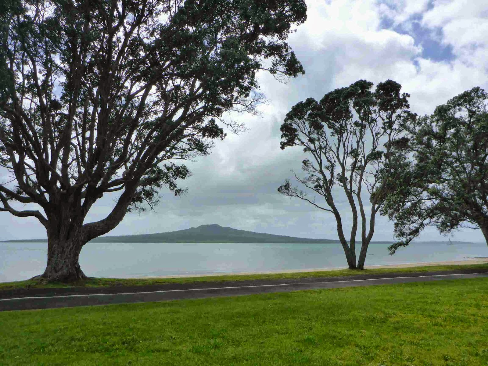
I then started walking the trail. It was lovely with a meadow of long grass and flowers on one side and river and sea the other. I caught my first glimpse of Rangitoto Island and the Auckland Skytower.


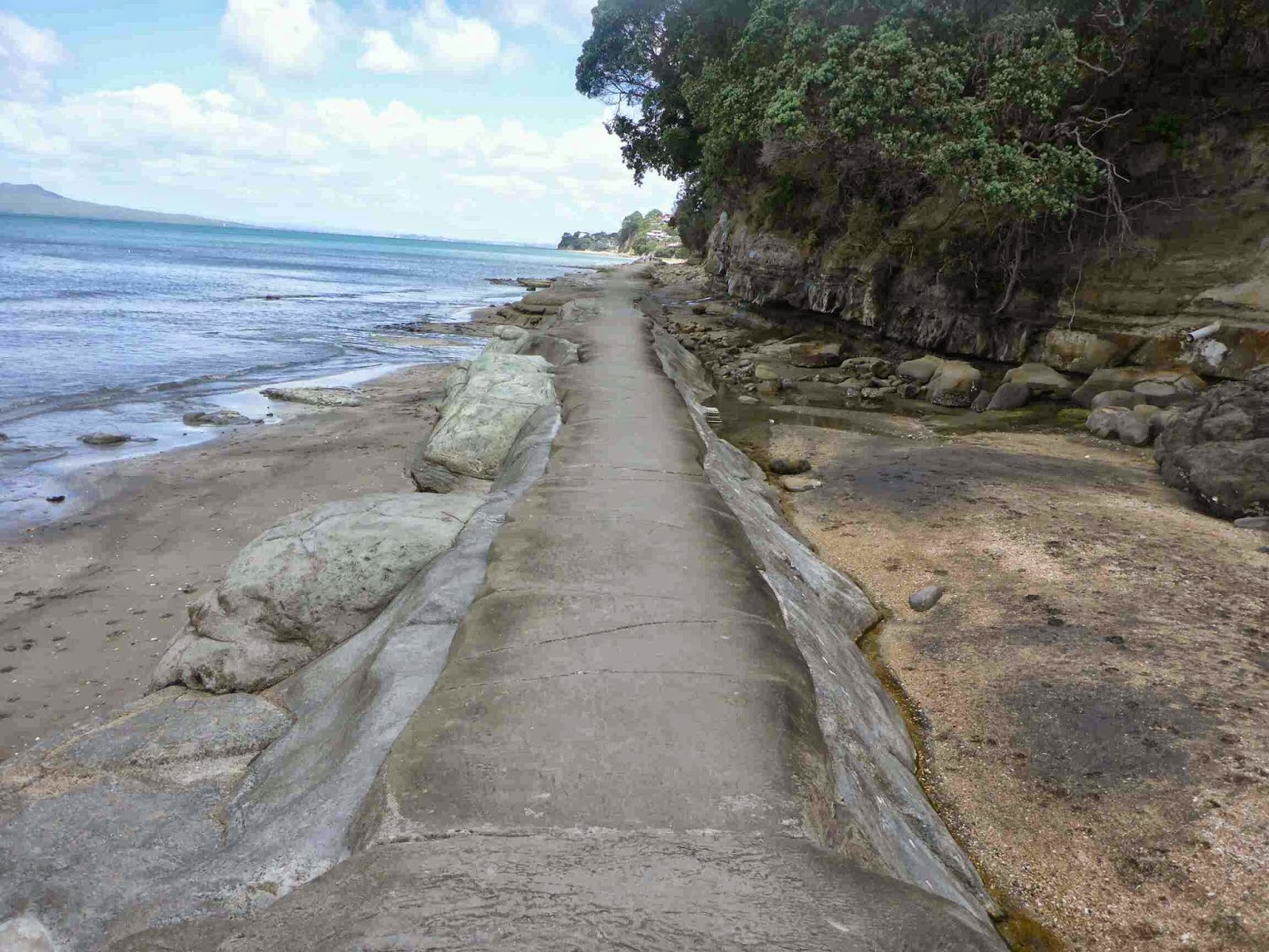
It was then a combination of beach walking, street walking and rock hopping down the coast. I loved the different rock formations that changed so quickly from one type to another.


I was feeling ready for a break so I decided to stop at the next cafe but I didn’t see any. This is Auckland the NZ cafe capital and I couldn’t find one. I had to settle for a park bench with a Pixie Caramel Chocolate Bar and water.
On one path a lady recognised what I was doing and congratulated me on the achievement. I had been starting to feel tired with my feet getting sore but after that little pick me up I felt better for a while. On Milford Beach I met David and Judy when David asked me about my walking poles and the benefit of using them. He and his wife (70 + & 68 years old) were planning on doing the 5 day peninsular walk in the Corimandel. I hope I am up to something as adventurous as that at their age. After a bit more of talking about life on the trail they offered for me to stay at their place for the night. I explained I already had a place but encouraged them to pick up tramper strays if they saw them in the future in the beach now they knew what they were doing. Fantastic and motivating people with kind hearts. I hope someone is lucky enough to stay with them in the future as I think they will have fun.
I had one more encounter with a runner who knew what I was up to and congratulated me for doing the walk. On the whole there were many more people about than I expected for a work day. I received a lot of curious looks walking along with pack and poles. Parts of the day I really enjoyed like the path between the rocks between Milford and Takapuna Beaches. Parts I did not enjoy were anytime I was on a hard surface as my feet were sore and I had a new blister on my left foot on the inside bottom of the heel. I have decided to get different shoes for the rest of the North Island as while these shoes are great on the trail they are not padded enough for road walking.
Today seemed to take a long time as it was hard to get into a rhythm as the trail was constantly changing but it was an interesting day.
I left the trail on Takapuna Beach and walked to Gil’s house. She gave me a fantastic welcome. First up was a wonderful shower and a real towel to dry myself with. Normally I use my camp towel which is the size of a man’s handkerchief. I put on a load of washing for smelly clothes, including camp clothes which are usually worn while everything else is washed (I didn’t wander around naked- Gil loaned me some clothes).
Gil then gave me a lovely cup of tea and we talked while she finished off dinner preparation. Gil had some great stories about cycling around France, her background and her immigration to NZ-twice. Diner was great. A spinach and feta pie (has a more fancy name that I can’t remember) with a lovely green salad, complete with avocado (just as i had fantasised about on Day 19). Understanding a hiker appetite she let me have a huge amount and the remainder is coming with me tomorrow. Desert was big juicy sweet strawberries, mint and yoghurt. After Dinner we had a brew and talked and talked. It is great to have such an easy free flowing conversation. Later Gill’s flatmate Melanie arrived and we talked even more. Overall a great evening and I have been blown away by Gil’s amazing hospitality to a total stranger. She definitely deserves the title of Trail Angel.
I drift off to sleep luxuriating in the Queen size bed.

20 November 2014
Day 23. Takapuna to Auckland City Centre.


I then walked down the hill and though Devonport to the ferry. Walking along I reflected on how far I had come. If it was taken separately from the whole TA journey it would be a great achievement, nearly 600 km of beaches, jungle, mud, bog, bush, forest, rivers and roads. The journey had been everything I hoped it would be and I have really enjoyed myself. I realise I have been lucky with the weather not having a single day where it rained the whole time. I think the longest continual rain I have had is only a few hours. As well as the landscapes and nature I have been lucky to meet some fantastic people as well. The friendly openness if most people makes me proud of being a kiwi and thankful to live in a country where it is possible to remain trusting in the good nature of strangers.
Once across the ferry I walked a small bit of the route then went back to Queen St. It was almost overwhelming having so many people around so I dived into the comfort of an outdoor shop, Bivouac. Here soothed by hi tech outdoor products I had a look at the shoes and selected the Solomon XA Pro 3D as my replacement shoe. I used to use these for trail running and hope they will be easier on my feet on the roads but still have the grip for the trails. It was a nice bonus that they match my blue colour theme. I also mentioned that my Icebreaker socks were wearing out around my little toe and I was immediately given free replacements as they have a lifetime guarantee. So I floated out of the store with bright new socks and shoes.


I arrived at the YHA International and spotted two Aarn Packs ahead of me. It was the Irish Couple Alan and Lauren who I had met at Whananaki. Unfortunately they were not feeling well after picking up a bug and had pushed ahead to Auckland to try and recover before rejoining the trail. Unfortunately for them the backpackers was booked out and it is likely most of them are as there is a big music concert this weekend. I would loved to have offered to share my room but I was booked into a 4 person dorm so that wasn’t an option.
I was 15 minutes to early for checking so I took a seat and waited. Once I checked in I headed for my room and relaxed.

It was nice not having to worry about racing around to do washing after having . I started working through my photos then went out for a coffee and returned to just sit around chilling out.
For dinner I walked to the nearby restaurants and decided on a chicken and cashew stirfry with ice cream for desert.
21 November 2014
Day 24. Auckland. Zero day.
Today was a day of no walking. I had been hoping for a sleep in but not really an option a dorm room. I did laze in bed for a while before heading out for breakfast at the nearby cafe. I had decided to go to the movies so I saw the latest Hunger Games movie, had lunch then saw Fury.
I did find it interesting when waiting to cross Queen Street (main road in city) observing the discipline of the pedestrians at the lights. The cars were blocked from moving forwards but keeping the crossing open. Despite no traffic moving none of the pedestrians crossed. We waited a couple of minutes with no cars moving and not one person crossed until pedestrian signal went green. The would have been nearly 50 people waiting and all obeyed the lights. Living in Africa this is unheard of.
Then it was diner time so I splashed out for a steak and back to the YHA to finish my blogs before bed.
22 November 2014
Day 25. Auckland to Manakau.


Being a Saturday there were heaps of people out playing Cricket (for those that don’t know this is a boring complicated game invented by the British that lays from 5 hours to 5 days depending on the version bring played. Play stops for rain or bad light and they have tea breaks. Personally not my cup of tea).
Then it was another short raid walk to Mt Eden which is pretty cool as it had a prefect cone crater and fantastic views of Auckland in all directions. One Tree Hill was easily seen and that is where the trail headed next.


I did a quick detour to climb to the top as I haven’t done that since I was a kid and there actually still was one tree on One Tree Hill (an activist chopped it down). From there I could see Mangarei Harbour my next destination.


The walk there took me through Royal Oak where I stopped for an early lunch and coffee.
The trail then headed a little down the road and into a little park then back onto the road and down to the end of the Coast to Coast Trail. I was surprised they was no marker or sign to signify the end. I headed up a park beside the road and then across a bridge over the motorwayand back down the motorway.


They are putting in a new overpass and doing construction. I got a fright when I saw a sign closed to everyone, including pedestrians on Saturday but it is for 29 Nov not today. I followed the road beside the motorway for a while. I passed a motel called Airport Harbour View which is a lie on both counts as it is not close to the airport and the only Harbour view might be a glimpse of water between the massive concrete tanks.
The trail then crossed the estuary on the old highway Bridge which is just for bikes and pedestrians now.


I then followed the Coastal trail for several to Amberly Park. Now this trail had a concrete footpath but it also had really wide grass strips as well so it was a really enjoyable trail.
Once in Amberley Park the trail followed a grass track around the coast. Along the way were some interesting information panels on the birds, geology and history of the area.


I saw a couple of trampers ahead and could not help myself from speeding up to try catch them. This is one of the reasons I prefer walking by myself. I am very competitive and would push the pace continuously to be as good or better than everyone else regardless of size, fitness or any other factor. I nearly caught up to them but they pulled into the camp ground so I didn’t get to find out of they were TAers or just day walkers. The trail then joined a gravel road and followed this for 7 km along the Watercare Track which is refurbished land from the old sewage treatment area. There were several areas protected for the birds and I was surprised to see Black swans. I thought these birds were fresh water but there was a big flock of them in the salt water.


The track went past the new sewage treatment plant and continued along the water edge until coming out at a car park with toilets.
The trail then narrowed to walking trail 1m wide and continued following the coast. At a small TA marker it turned off the nice trail and followed paddocks to the end of the trail. I decided to follow one of the short withs through the Otuataua Stonefields and was a little disappointed that it was just rocky paddocks. Maybe I missed something.


Back on the trail I passed the Avocado Orchard gifted by someone to the community which everyone can help themselves to 5 avocados for free. I couldn’t see any avocados so I moved on. The was a series of shortish road walks and then I was at the airport. The great things about the roads near the airport is their great has verges.
I stopped in at McDonalds for a smoothie and small fries and they gave me a cheeseburger for free. They must have seen the hiker hunger as I gazed longingly at the menu. While eating I started taking to the lady beside me after the usual curious look at the pack and horror at the speed I was inhaling my food. She was fascinated by the thought of the trail and knew someone she thought might be interested in doing it so she asked lots of questions which filled in the time and forced me to eat at human normal speed, not thru hiker speed.
I then continued out of the airport area and heading towards Manakau. It was pretty neat walking under the fight path of the big planes as they were coming in to land.


After 3 km out was a right into a little County road and 1 km later I was at the Puhinui Reserve. For a little quiet Reserve away from a city and not signposted I was really surprised how flash the toilets were. They were the electronic ones where you press a button to lock your door and then a polite man tells you the doors will unlock in ten minutes. Then I was treated to music while I did my business and was wished a nice day as I left. I wonder which person on the regional council thought that was a good use of rate payers money, nice as it was for me and the 1 or two people a day who probably use it.
From the fantastic toilet it was following a fence line with a heard of curious cows following. The track then turned into City Park standard and followed the steam for 1.5 km before emerging through an industrial part.


It was then on the main road for a few hundred metres and then onto Wiri Station Road which is usually really busy but was almost deserted. I looked at the time and realised I would have to pick up the pace to make check in time at the holiday Park so I could pick up my resupply parcel. I changed gears and started power walking down the road. I quickly reached the junction where the trail cut through a park but I must have missed a TA arrow as I ended I coming out of the park in a different place than I should of. I quickly identified where I was and was off again with 1 km to go.
On getting near to where the holiday park was I was concerned as there seems to be a new development where I expected the Park. I looked at my map and decided to go another 100 meters and then turn on my phone to Google the address. Just after that I saw the sign for the Holiday Park to my relief. I checked on and the lady asked for more that what I should be paying. When I questioned it she appologised and said I had been up upgraded but she missed the note. I had booked into a basic cabin and ended up with one with a queen bed and kitchen-no complaints about that.

After settling in I walked up the road for fish and chips, fruit salad and fruit juice (I am craving fruit and fruit juice at the moment). Then after phoning my Parents to give resupply instructions, and just to talk, I went to sleep in a snore free zone.
23 November 2014
Day 26. Manakau to Hunua Falls.


I decided to have a quick look around some of the gardens then back into the trail through to Totora Park. I was on familiar ground now as when I was based in Papakura I did a lot of running around these parks.
At the end of the parks it was footpath bashing to get out of the suburbs.


Once we turned into Alfriston Road I stopped enjoying myself. This was a really busy road with no edges to walk on. It was 6 km on this road and this seemed to take ages. Because I had to stay so alert to the traffic I couldn’t zone out like I normally do and I couldn’t look around much at the scenery.

Finally that torment was over and I turned into Twilight Road
Now the were very few cars, there were trees for shade, the birds started singing and the animals frolicking – cue soppy happy ending music.
Ok turn the music off, there is more walking to do.
Twilight road turned into Kimpton Road and now there was no traffic at all. Just as I was going past the Palm Farm (now I know where to come if I ever want a palm tree in Auckland) a big flock of Rosellas flew past and they were flitting around the trees. Rosellas are the most brightly coloured birds you will see flying around NZ. They are bright green and have patches of yellow, red and blue. Now I was really back to having fun again.
At the quarry the trail headed right up a gravel road for a km then into farmland heading up the hill. On the gravel road I was surprised when a flock of sheep came running up to the fence as I approached. I am used to curious cows doing this but sheep always run away.

As I was climbing the hill I was laughing thinking the TA trail setters must have been thinking “hmm no big hill between Manakau and Clevedon. That is not fair for the walkers to have a flat day. Ah there is a big hill, Let’s put them up that”.
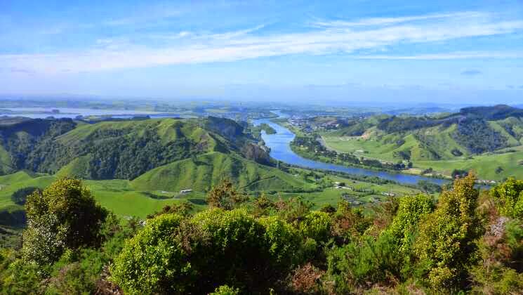
The trail was steep for the first bit but it was great looking back towards Auckland.

.jpg)
The trail then went through some forestry up to a trig, down through a gorse corridor and then into the bush to meet up with the Clevedon Reserve Circuit. Shortly after I came to the lookout which has fantastic 360 degree views and I saw the Auckland Skytower for the last time. At the lookout were two ladies and their children. The topic of what I was doing came up and I laughed when one kid was asked if they would like to walk for so long and he said “no way too much work”. When I mentioned no school the answer changed to “yes”.
It was then a steep descent on many stairs to the bottom and then into Clevedon where I hoped to get a coffee. I was gutted I did not make it to Clevedon before 2 as then I would have been there for their Sunday market which is great. I arrived at 1445 and while I knew the market was over I was sure the cafe would be open but I was let down as they were closed for a private function. I didn’t really need anything but a flavoured fruit juice would have been nice. Next to the cafe is the Wine Shop which sells souvenir things. I poked my head in on the off chance they would have drinks but no, only tea leaves. However the young sales lady have me directions to somewhere that may have drinks (200 meters away) and then offered to fill up my water bottles. I continue to be impressed with the level of service received every where in NZ. I had forgotten how good it is.
As I couldn’t get the energy to walk the 200 metres to the other shop I continued on my way. I did poke my head into the pub to see their drink range but nothing stuck my fancy so I continued on. After crossing the Clevedon Bridge the trail turned right and it was 5.5 km of road walking which I plodded along at an easy pace. I was entertained by old fighter planes from Ardmore Aerodrome practicing formation flying.


Finally the road walking for the day was at an end and I was heading into the bush. When looking at the map I expected a rough trail but it was a lovely fast trail. The were a couple of small muddy bits but these were drying out and easy to get around.


The trail was flat for a couple of km then there was a small hill. It was here that I met Scott and his two dogs. He lives near the trail head and does a lot of trail maintenance to keep the trail in good condition. This is done voluntary which is fantastic. He gave me some good advice on camping spots. On his advice I decided to push on to the Hunua Waterfall. The trail continued to be good all the way to the turnoff to the waterfalls. They are only 5 minutes off the TA trail and well worth the detour.
While waiting for the day visitors to leave I cooked dinner and put on some trousers as protection against Sandflys which were out in force.


Finally around 1940 most people had left and I headed back to the waterfall. There was one couple left and they were taking ages taking photos. I then started talking and they were fascinated with the concept of TA. They wanted to see my gear so I gave them a demonstration of my tent going up and showed them some other stuff.

Once they had left I had the place to myself and was able to settle in for the night. I drifted off to sleep to the sound of the waterfall, which was actually quite loud but did not stop me sleeping well.
24 November 2014
Day 27. Hunua Falls to Mangatawhiri River Swingbridge.

Eventually I started my morning routine and left at 0730. The track was easy though stairs first thing in the morning is not my favourite way to start the day. I was definitely the first one on the trail as I was breaking lots of Spiderwebs and getting them all over me. I had visions of the silk threads flying behind me like Prescilla Queen of the Desert.
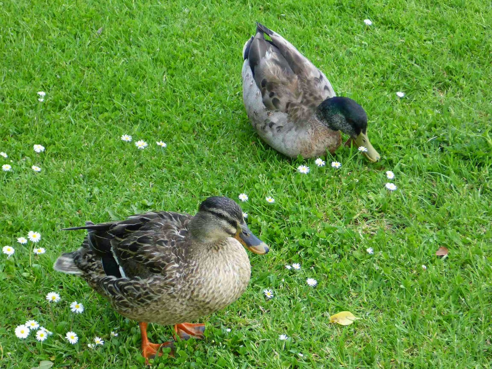
I was also amused to come around a corner to see two Ducks waddling up the track.


After 40 minutes I came to an intersection. The way I was on was marked Massey Track and the other had no markers. I checked my map and this other trail seemed to head in the direction I wanted to go whereas the main trail seemed to be in the wrong direction. There were no TA markers but there were lots of footprints so I decided to take the track. It was interesting that the track markers were white triangles rather than the usual orange. It was a lovely track and I was making good time. The track started to go down steeply which I thought was a bit strange but I was distracted by the stairs and ropes for the descent.


Then to my surprise I came out to farmland. I realised what I had done, I had come off the ridgeline on a spur on a track not marked on my map. I briefly looked at the road option to meet back with the trail further on but decided to go back up to the junction. It only took me 20 minutes to get back up as I was so mad at myself. When I got back I saw I had wasted an hour by being stupid.
So take 2. I arrived at the intersection and checked my map which confirmed that I was meant to be on Massey Track and despite the direction seeming slightly off I continued on the main track thinking who would be stupid enough not to go straight.
The lovely wide and well maintained track continued another 15 minutes to an intersection that clearly showed the direction to the Wairoa-Casseys Track to the right. On the orange marker someone had written in pen TA directions.
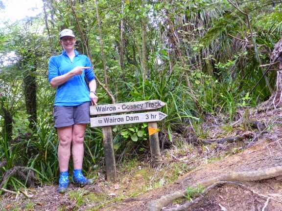


The sign said 3 hours to the track end. The track was quite boggy and slow going so thought I might take the full time but then I reached the half way marker in 1 hour and realised it would be much quicker. It was a novel thing having a half way marker.
The track then improved and I was able to pick up the pace and quickly reached the track end after 1 hour 45 minutes.


The main trail went straight and the other was for “Suspension Bridge Loop”. There were no TA markers or comments in the trail notes so having learned my lesson I kept on the main trail. At the lookout I climbed for a look but the trees had grown too tall and you could not see anything. I kept going for another 5 minutes then realised I was heading away from the Dam. I had another look at my map and could just make out the track I was on which was the wrong track – Grrr. I now turned around and climbed the stairs and hill again all the way back to the track junction. Another 10 minutes wasted. I wrote in the moss on the sign “TA” and an arrow pointing to the right track. It was a quick descent to a much better lookout and then to the bottom where there were picnic tables where I had lunch.


The track then crossed the dam and continued on a gravel road to the next track up the Wairoa Track Loop. This was a lovely track which climbed steadily up to the Cell phone Tower.


There the trail followed a gravel road out to the Mangatangi Hill Road. Here there was a discrepancy between the trail notes and the map. The trail notes took the road down to the valley and then followed roads to the valley to the end before heading up to the ridge to join the next track. I had done most of these roads before so I decided to take the route marked on the map which followed the DOC track on the ridge. This track was of variable condition. Sometimes awful and sometimes ok. It was a lot of up and down and the other way was probably quicker but it was nice not being on roads.
The weather continued to be low cloud with the tops in mist. Despite this I was hot and drinking heaps. I was nearly out of water for the last track of the day which meant I had to get through the track to the Swingbridge where I could refill my water before camping.
The two tracks met up and then the next track started. I had read a lot about this track on people’s blogs and the warning sign at the start confirmed this would be a challenge. It was for the first km and a half. The track was well marked but overgrown, slippery and rough and I had to take it really easy. There was lots of Supple Jack Vine which doesn’t like to be ignored and has this magical property of jumping and attaching itself around your leg or pack when you are sure you were clearly past or had loss of space. Anytime I felt the slightest tug I stopped and cleared it. I tried to move with the bush rather than try to fight it which while slow and deliberate was probably quicker than if I tried to rush.
The good news is that the track, while muddy and slippery, was not boggy. The second good news is that the track did improve steadily and for the last km before the descent the track was great as it went through beech trees. The final good news is that the downhill was dry and easy going. About 1/3 of the way down it became a wide track which zigzaged gently down the hill.


I made it to the Swingbridge after 2.5 hours from starting and found a nice campspot to pitch my tent.


Before the tent though was filtering some water as I was desperate for water by this time. I has rationed at 1 sip every 30 minutes and then had nothing for the last hour.
I had a coffee and then a hot water and electrolyte drink before dinner of Sweet and sour lamb freeze dri followed by Butterscotch Instant Pudding which is still my favourite.
I went to sleep listening to the wierd noises of the bush at night. You definitely don’t want too active an imagination when camping by yourself.
25 November 2014
Day 28. Mangatawhiri Swingbridge to Te Kauwhata Pumphouse.
I left at 0730, back into my normal routine. It was a quick 30 minutes on a nice track through the bush to the road end and then 5 km of road walking which I didn’t mind as it was nice to stretch the legs and look around without having to worry about where my feet were going. It was the time of the morning when the farmers were feeding the calves so it was interesting to watch as I plodded along. There were also a lot of birds about and I was able to get close to a couple of Rosellas which were feeding on the road.


The weather was the same low cloud and occasional misting rain as yesterday. It got heavier for 10 minutes so out came the umbrella. It was also still really muggy and I was sweating continuously and really thirsty. This continued all day and got worse when the sun came out for a couple of hours.
After an hour I was at the highway but due to rerouting I was only on the highway for a couple of hundred meters before crossing under the bridge and up onto the stopbank which I followed for the next 6.5 km. I really enjoyed this part. The track was generally good though the grass was long in places. There was a constant racket from both sides of the stopbank from birds, crickets, frogs, ducks and geese.


My feet were soaked from the wet grass and my new shoes inner soles apparently do not do well in the water. After 3 km of wet feet one started to scrunch up causing ridges under my feet which is very uncomfortable. I tried putting my orthotics in but these shoes are already very supportive
and the orthotic was uncomfortable after a while. I tried squeezing all the water out of my socks and the inner sole but this would only last a couple of minutes and they would scrunch again. After another km the other one started doing the same thing. It was so frustrating. Eventually I just took the inner soles out as this was the best I could do.


At the end of the stopbank there was a 1.5 km gravel road walk and then single track through some trees and under the motorway bridge to get across the other side of the motorway. The neat little track then continued to Mercer. For some reason I thought there was a subway there and I had been thinking about what type of sandwich I was going to have. Unfortunately no subway so I had to make do with McDonald’s instead. After that I bought a fruit drink and Ice cream to help me on my way.
I crossed over the motorway and headed up a steep hill which changed from road to farmland and the track the followed parallel to the motorway going up and down some steep little hills. In this area there were heaps of Skinks. I was afraid I was going to step on one. A couple of times I nearly did but fortunately most of them had the sense to go off the track when they heard me coming.


The track ended at the site of an old British fort from the Waikato Wars. Then down the hill and over the railway line and under the motorway. For a short time there was a nice track through the trees but then it was walking on the grass beside the road to Meremere. Last time I was there it was still single lane and the old power station was there. Now it is a motorway and the power station is something else.
Shortly after there was a small bridge and that was the start of the river trail. It was now 11.5 km along the river by farmland, stopbank, trees and the occasional gorse patch. The track was generally good but there were a couple of not so good patches but even they were ok. In preparation for camping I filtered some water from the river though I was all a little dubious about drinking this as the Waikato River has a bad reputation for waste quality however I put my trust in my Sawyer Water Filter.


The misty rain returned which was not heavy enough for a jacket but got the grass wet again and my inner soles started scrunching again. Lucky my campsite was in sight when they did this so I just put up with it for a couple of minutes.
I set up my tent under some trees for protection from the wind and rain and finished off my night routine. As I was thirsty from the humid day I had a cup of tea before my soup and dinner was Mexican Chicken Freeze Dri. Desert was just a lollie tonight. The final sounds of the night was the wind ripping through the trees but I was nice and sheltered where I was.


26 November 2014
Day 29. Te Kauwhata Pump house to Hakarimata Range (TA km 765).
Within 5 minutes of starting my left shoe inner sole started scrunching up again so I took it out. Then 10 minutes later the right one also did the same so that one came out as well. Luckily there is very little road walking today but I was really annoyed and a little worried how my feet would survive with no inner soles for the next two days.
For a short while I was entertained by a farmer moving dairy cows to a new paddock after milking. For some reason rather than get them onto the road and then along the road into their new paddock he moved them through another paddock that had lots of grass. By the time he got the far gate open the cows had settled in and did not want to move. When I went out of sight 5 minutes later he had still not successfully got any of the cows out of that paddock despite much yelling and racing around on his motorbike.


I decided to divert off the route in Rangiri in order to get a coffee and snack. This meant crossing SH1 and following beside it for a hundred meters. Luckily there was room on the other side of the safety rail. I tried the flash public toilets there but was not impressed. Everything was push button including getting toilet paper but there wasn’t any paper. Then for washing your hands there were sensors to give soap and water. The trouble is when you held your hands under the picture for soap the soap squirted in a different place and it would only give one dollop. For water you only got two small squirts which wasn’t enough.

Then to top off my Rangiri experience the cafe was closed. I was really annoyed at walking an extra km for no benefit. Just as I was about to walk away the owner arrived and opened up (1000) and Rangiri was off the black list though he was only selling cold drinks and Ice creams. Apparently his cook had run off and he couldn’t find a replacement so he was closing the cafe and giving up the lease. I had a Poweraid and ice cream and chatted with the owner for a while. Just as I left a light misting rain started up. It wasn’t enough to bother with a jacket for and it was too warn for a jacket anyway, I would have been sweating so much I would be soaked.
After negotiating my way down and over the highway again I crossed a one lane bridge that had a nice raised pedestrian path.

It was then onto stopbanks for the next 9 km. You may think that would get boring but it is not as bad as you would think. The terrain changes every time you cross a stile, which you do a lot. Sometimes you have the perfect short grass and smooth ground. Then you could have the long grass and the ground could be rough due to cows walking on it when wet, or any combination of these. There was also the weather giving some variety between rain, light mist and just overcast. With the rain the grass was wet and my shoes were soaked. I don’t like these shoes lack of drainage and I stayed squelching continuously There is also cows and sheep to look at. The misty rain cane and went and a couple of times got a little heavier so I got my umbrella out.


As I came around a corner on the stopbank I could see the Huntly Power Station chimney and I got all excited. I started singing out loud which is the first time I have done this. I survived the beach and bush without singing but it is the stopbanks that cracked me. Unfortunately my memory of song lyrics is not good and nor is my voice so I felt sorry for the animals around having to listen to me. I soon calmed down when I checked my map and realised I still had quite a way to go.
The trail went past the golf course with the notes saying keep to the edges for safety. I think it was to keep the riff raff out of sight, and smell, which is a sensible move on their part.
It was then some more stopbank walking, then 1 km of road. Here I met John. He is on a 3 week cycle tour of NZ. He stopped when he saw me and we chatted for a while. He is an Australian who was also in the Army, though the Australian one. He is now retired and does cycle tours a few times year to NZ and Europe. After that nice break it was more stopbank and the final road section before a short walk through trees to the sculpture park in front of the Power Station.


I wandered through to see the sculpture and sat down there to wring my socks out and try putting my inner soles back in as there was road walking ahead. 2 minutes later I had to take the left out again but the right one stayed ok for the rest of the way.
I stopped in Huntly for a burger, chips and some pineapple fritters as a late lunch before the final 4 km road walk.
This seemed to go really fast and I reached the turnoff well before i expected to. It was then 800 meters up the road to the Hakarimata Reserve for the start of the Hakarimata Track. It was straight up to the top via lots of steps but this only took 20 minutes to the upper lookout which had great views back where I had come from back to the Hunua Ranges. 10 minutes on was the southern lookout where I could see Hamilton and Pirongia where I would be heading to.


Then it was following a great rooty track along the ridge line up and down. When I looked at my watch the time had flown by as I was really enjoying this track. I saw it was time to look for a campsite and 10 minutes on the track came out onto an old grass vehicle track which made a lovely campsite. I could look out across the Waikato from my tent.


I wasn’t hungry after my huge lunch so I just had soup, tea, a pineapple fritter and some instant pudding.
Looking out my tent door I watched the clouds turn red with the sunset and the lights stay appearing below.


Visits: 1418
27 November 2014
Day 30. Hakarimata Range to Hamilton.
The track continued in the same way with lots of roots and I continued to enjoy it. After only one and a half hours I reached the lookout and was rewarded with fantastic views. I could see all the way back to the Hunua Ranges and looking South I could see Mt Pirongia which I was heading for.
From here the trail improved to Walking Track standard which means wide gravel paths and stairs. I remember doing this part of the track with my mother back when I was in high school. It is unrecognisable now with all the improvements. This has had a positive effect in opening up access to more than dedicated trampers. I saw 13 people heading up for some exercise which is way more people than I have seen on any of the trails.
After a quick descent I reached Nguarawahia and decided after that effort I deserved a coffee. I headed into the main part of town and spotted to take a photo of an impressive statue on the park outside Turangaweiwei House.
There I had the good fortune to meet Clem. He had just driven the Hamilton Mayor and some council members off for a meeting and was having a break. We started talking about tramping and the trail. He is also a tramper and shortly be will be doing the Hollyford Walk with his wife and daughter. He offered me some coffee and a lovely slice which I greatfully accepted. I sat down at the table and we talked some more. Eventually the subject of where I was staying in Hamilton came up and I said I was staying in a Backpacker. He instantly offered for me to stay at his house which was by the lake and not far from the trail. Once again I accepted, especially when he mentioned Spa pool. He rang his wife, Patrica, who agreed.
I said “see you later” to Clem and continued on my way. The trail followed the river going under the SH1 Bridge and past the Turangawaewae Marea, home of the Maori King and then cut back to SH1 for 5 km because the freezing works will not allow access to the river in front of them. Interesting the amount of road kill in front of the freezing works. Maybe animals sense the death there and get distracted. Also a bit mean for the cows in the paddock looking across and smelling the place they would be killed. The smell was not pleasant.
The trail heading back to the River Trail where it trail stayed apart from 2 km just after Fonterra (which smelled lovely with the milk powder processing) until Hamilton. This is an amazing trail that is nearing completion which will make it around 70 km long shared use wide concrete trail from Nguarawahia to Cambridge.
Fortunately the thought of a concrete trail does not make me wince anymore as my new shoes have much better padding.
Nothing particularly interesting happened but it was nice walking along the river looking at the houses and rowers. Eventually I made it to Hamilton and I went first to the DOC office to get a 6 month Hut Pass which for $92 gives me access to every Hut in NZ except the Great Walk huts. The first Hut of TA was on Mt Pirongia. Unfortunately they were closed for the next two days.
I then headed to Bivouac to explain my inner sole issue and they did not seem too invested in the problem and did not pose any solution. Their comment was they had not heard of this happening before. I was surprised as usually Bivouac customer service is excellent. I ended up buying some inner soles and after asking got 20% off them.
Next was back onto the trail through Garden Place that doesn’t seem much different from when I last saw it 20 years ago.
The trail then goes through a mall (how many long distance hiking trails do that?). I stopped for a fresh squeezed juice that I had been fantasising about and it was fantastic. I also had some sushi to take the edge off my hunger.
Then it was on the road up and over the hill to the Lake trail. The Lake was smaller than I remember and I do not remember any Pukeko of which there were heaps. They were so used to people I could get really close. The were also some birds that sort of looked like Pukeko but were Black with a white thing on their head and cool blue feet.
I left the trail at the head of the Lake to make my way to Clem and Patrica’s house and meet up with them on the trail as they were taking a walk. Instantly I felt comfortable with Patrica which was a relief. I knew I liked Clem but there is always a slight gamble in how one partner will react when the other invites a random smelly stranger to stay for 2 nights. I needn’t have worried. Patrica is just as warm and welcoming as Clem and as a tramper herself, understanding of what I was doing.
They were fantastic. I was shown my room and it was like a fancy hotel with towels laid on the bed and even a Whittakers Dark Chocolate Bar presented beautifully. I was taken on a tour of the house which is beautiful and then given time to clean up. I loved the little touches they have put in when renovating their home. In the bathroom it had tiles and then some river stones in the walls that made me think of the South Island. I had a wonderful shower and put my smelly things into the wash before joining Patrica and Clem for a drink and some conversation. We had a lovely dinner and very impressive desert, regardless of Patrica saying it was simple. We then talked some more and I showed them all of my kit. Nice to have people interested and appreciative. Then it was bed time.
28 November 2014
Day 31. Hamilton. Zero day.
I then settled into the couch looking over the lake and caught up with the world on Internet before starting to work on my blog. The weather cleared so I thought I would try out the Spa Pool and it was amazing. Sitting in the warm water looking over the Lake was very relaxing.
Eventually I emerged and had another shower then made some lunch and another cupaccino before getting back to my blogs. Patrica, Clem and Chris (I think that is the name and if not sorry) returned from their hike up Mt Pirongia and we chatted for a bit then I showed Chris my gear as they had been taking about it and TA in the car. I may have infected then with the TA bug as they are now taking about section hiking it over 4 years. Chris left and I just relaxed until dinner time.
As it was Friday night they have a special pizza and movie night. Clem made an amazing chicken and apricot pizza that I had to eat some of to have room for salad on the plate. We watched Salmon Fishing In Yemen which I had never seen before and enjoyed. After the movie we chatted for a while then it was bed time.
29 November 2014
Day 32. Hamilton to Kapamahumga Range.
I was woken by my alarm this morning which is unusual as I have normally been waking up unassisted. It must be the comfortable bed and feeling relaxed. I went to the kitchen to have some cereal and Patrica was just coming back from the shops with milk. She offered some poached eggs which I couldn’t say no to and then offered bacon as well. I ate my cereal and drank my cappuccino while she worked in the kitchen and then she preserved me with a masterpiece of 2 pieces of thick toast with a very generous helping of bacon, 2 farm fresh poached eggs, a lovely sauce and a light sprinkle of pepper. I challenge the best cafe to try and produce something that looks and tastes as good. Then while we were talking Patrica made me some sandwiches and packaged the leftover of last night’s pizza. I find it amazing that Patrica is so giving and genterous and doesn’t think she is doing anything special. After that magnificent breakfast I finished packing and reluctantly said my goodbye. Patrica and Clement have been amazing in their hospitality to a smelly stay hiker and I really hope we keep in touch as they are great people.
I walked back around the lake to where I left the trail and was on the streets for a short walk to the Dinsdale shopping centre. It was lovely blue sky when I started but 5 minutes later the grey clouds rolled over and then there was light rain which I kept off with my umbrella. That lasted a couple of minutes and then it cleared.
For some reason my knees were a little sore today and my right shin was also a little sore. The only thing I can put it down to is my new inner soles.
Just as I got to Dinsdale it stated raining heavily but I was able to shelter under the shop awnings. I went to the Post Office and mailed some stuff back to my parents to look after. It is mainly things I had included in my resupply parcels that I did not need. I then went to the supermarket to buy lunches and snacks for the next 4 days.
I finally left at 1130. After 1.5 km I was on Tills Lookout which I had never been to desite Hamilton being my old city (though in my defence I lived 30 minutes outside the city). There were nice views of the city. Then 10 minutes later I reached the Taitua Arboretum. This was another thing I didn’t know existed. It was a large piece of land where different trees were planted. There were nice gravel paths and good maps and signs showing where the different types of trees were.
Just as I got to the end it started raining harder again but conveniently there was a shelter to take cover under. I was joined by a guy with two Chocolate Labradors who were very interested in my snacks. He was a Hunter and we talked abut packs and gear. He usually carries a 90 Litre pack!
When the rain stopped I left and there was 1.5 km of road walking and then onto a trail through farmland up and down many little hills. It was near the end of that I realised I had missed another 100 km milestone so I did a photo for 804 km.
After the farm trail there was 3 km of road walking that went quickly and I was in Whatawhata. Now I was really on familiar ground as I drove past here thousands of times when I was in high school. I grabbed a fruit juice from the service station and sat to eat the sandwiches Patrica had made. They were delicious and very filing.
After crossing the Bridge over the Waipa River there was a trail beside the river. It started out in trees then came out onto farmland. There was one herd of Heifers who were very friendly and really crowding me on all sides. When I stayed waking again they were right on my heels. Obviously the memory of the farmer feeding them as calves was still strong.
The trail ducked back onto the road to cross a steam by the road bridge then back into the fields but now there was very long grass to get through. Then I crossed into a field growing something and it was really hard work making progress around the edges.
It was then up Old Mountain Road for 4 km to the start of the Kapamahumga Walkway. It was in this Walkway, though heading north not South, that I first got the spark about how tramping the whole country would be cool (see my very first blog for more on this). it was neat to see some of the old NZ Walkway signs were still there. The trail followed the ridgeline through farmland with spectacular views over Hamilton and the surrounding farmland. The only bad thing was the wind was freezing and I had to zip my top up and put my sleeves down which I don’t do often.
Once we came off the ridge line the trail entered a patch of bush for the descent and I found a nice campsite for the night.
I ate the last of the Pizza for diner with some Biltong I was really happy to find in the supermarket followed by fruit leather.
All it takes is a full stomach, cosy tent and knowing you have achieved some interesting km to be happy.
30 November 2014
Day 33. Kapamahanga Range to Te Rauamoa Road (over Mt Pirongia).
From the track it was a short 2.5 km road walk. The mountain was covered in cloud and it looked like it was raining up there.
The Tahuanui Track up Mt Pirongia started as an old vehicle track but with the wheel marks done as two nice paths in gravel. This track followed the river until the campground. Then it turned into a standard tramping track and I really liked it. Enough roots to be interesting but not enough to stop me really looking around while walking. It was a steady climb and moved through a few different vegetation zones. This tramping bliss ended as I reached the main mountain ridgeline. Here the bogs started in dark thick mud. The ridgeline also went up and down quite a bit. And it started raining.
Once the first junction was reached the standard of the track improved a little and there were even some boardwalks. Just as I was approaching the summit the rain started coming down harder and the clouds closed in so I couldn’t see anything from the summit lookout. The wind was really strong and driving the rain nearly horizontal. Luckily it was only 20 minutes to the Hut.
The new hut is finished and is just waiting Council structural consent but closed until then. I went into the old but which is cute. Strange that the mattresses have been removed except one. I decided to take an extended lunch to see if the weather would clear. Once I finished I still waited. Every time I decided to leave it woud start training even harder. It was hard getting the motivation to go back out into the rain when I was in a warm toasty hut but 1400 was a little early to stop for the day. Eventually another person turned up and that was my motivation to move on. Thankfully the rain had stopped though the wind was still strong.
I now took the Hihikiwi Trail which for me is awarded the WORST TRAIL award for all of the Te Araroa Trail so far – Yes even worse than the Raetea bogs.
The trail started beautifully with raised boardwalk for the first 700 metres. I was surprised that the were no handrails given the height of the boardwalk. I had no issue with this except in one part which was exposed the wind nearly blew me off.
Once off the boardwalks the first 50 metres was great and I thought ” neat no bog, this will be a quick walk down.” Ha how wrong was I. It turned into 5 km of continual bog and steep rooty ups and downs and I was really worried about hurting myself. For those who did the Raetea Bog imagine this. Take the Raetea bog and change the mud to dark brown almost Black. Now add lots of slippery roots to the mud. Now add steep ups and downs – continually. For real effect add rain. Finally make this 5 km long.
I was mentality very tired and just wanted the track to end. The trail notes and DOC information boards had said there were steps for the descent and I imagined this meant once we started going down off the ridge. I kept on looking for the stairs thinking they must start soon. I had a mental refrain on loop “where are the stairs, where are the stairs”. There were the occasional random 5 metre stretch of boardwalk. I think these were someones idea of a practical joke as they were so random and few and far between. Also they were often impossible to get to, or get off, due to the massive bog they were in. My walking poles were disappearing past the first adjuster regularly. There was one extended section of boardwalk which got me excited but sadly it was back to bogs. I nearly pulled out my magic motivation improver, Wonka Rasberry Twister. In the end I made a deal with myself that I would have it at the end of the trail. By the time the trail ended I was so happy to be done I forgot about my treat so it is still intact.
It took me just under 4 hours to do the 5 km downhill with the DOC time 4-5 hours (going up was 3 hours 15 minutes with DOC time 4 hours 30 minutes). I did note at the bottom the DOC time was 3 hours 30 minutes to the Hut which seems fast.
Less than 3 minutes from the end the stairs started. I wish they hadn’t even mentioned them as there were so few and right at the end.
Once on the road I just wanted to get as far away from the Hihikiwi Horror as possible so I walked a few km before looking for a nice campsite. Once I found a nice campsite I settled in. I hope I don’t have nightmares about that horrible track tonight.
Answer: Ponga bark (a type of tree fern common in NZ)
1 December 2014
Day 34. Te Rauamoa Road to Waitomo.
The day started on roads. First a lovely gravel road with views down to the Kawhia Bay, looking over the Tasman Sea for the first time since Ahipara.
After 3 km out was onto the SH 31 for 2.7 km and then onto another lovely gravel road for 7 km. I enjoyed this road because there was no bog and it had native bush for most of it and great views over green farmland for other bits.
The sun was occasionally making an appearance and I finally warmed up enough to take my jacket off, only to have to put it back on 5 minutes later when a heavy shower come through. The day stayed like that with blazing sun one moment then the sun disappeared behind a massive grey cloud which caused the temperature to plummet and icy rain for 2-15 minutes and then repeat.
Once off the road the trail followed farm tracks for 3 km then into the bush on an old logging road that was now a lovely wide single track through the bush. There has obviously been significant maintenance on this trail recently and judging from the amount of cut vegetation on the ground it was very overgrown before this. The trail was quite flat for most of it and near the end it climbed up to another farm trail. The trail had a few small bogs which I sloshed through but not too bad.
Often I could hear something moving in the bush and I assumed it was goats. Shortly after the strong aroma of Billy goat would waft past to confirm this. I saw a few glimpses of the goats but they were pretty quick diving off the track when they noticed me.
The farm trail led to a farm road and onto a gravel road for 1 km before heading back into the bush on a very strange trail. Most tracks in NZ travel along a river/stream, along a ridge or are in transition between these. The reason is this is the easiest way to travel in the bush. This trail seemed to be contouring around the hill, occasionally going up and over a ridge. This meant there was a lot of sidling which is the must difficult type of travel. I find it much easier to go straight up or down rather than trying to move along the side of the hill where you have to work harder to keep your balance and stop your feet sliding. The theory of sidling around a hill is to have less climbing but you still have ups and downs getting around the reentrants (gullys where streams go down).
This track was all over the place and I lost my sense of direction which doesn’t happen often to me in the bush (in a city is another matter).
Finally (only 1.5 km later) the track got onto a ridgeline and stayed there for some easy travel for a whole 5 minutes. I crossed a farm track and then the trail notes said follow markers over the high point but keeping to the strange nature of the trail we actually went around it and ended up at a fence line which we followed down – straight down very steeply. From the top I could see where the trail was going to go following a ridgeline with lots of big ups and downs. Unfortunately a particularly heavy shower had just passed over so this made the trail even more slippery. At times I was lowering myself down by the fence posts. This was a big descent and I was happy to make it through without slipping.
The trail now followed the fence line. Once again there had been some good trail trimming of vegetation but the pigs were making a mess rooting up the ground near the fence. On the other side of the fence was a lovely dirt road but I resisted the temptation as there was obviously a reason we were on a track between the scrub and fence rather than on the road.
After some ups and downs we crossed the fence and at the bottom of the hill was a stream to cross. I took this opportunity to wash out the last of the Pirongia mud from my shoes and socks and soak my feet in the icy water.
The trail then headed up and up and up steep tracks to the ridgeline where the trail entered the bush on a track with no name.
I really loved this track. It was dry, open, not many roots and did I mention DRY! This track was only 1.5 km before joining up with a very old vehicle track which was really just a wide single trail. This was also really nice for a while until the junction then it started going down and got a little slippery but not to bad – nothing is too bad after Hihikiwi Horror Trail. The trail then followed a small river and then crossed it. It was only mid shin deep.
The orange triangle markers stopped at the river making me wonder if this was the route. I looked at the only other possibly but it ended in a campsite. Normally there are clear markers on both sides of the steam.
The track was then a clay track with horse and mountain bike tracks on it. 10 minutes later there was an orange triangle and I felt better for the confirmation of being on the right track. Because of the speed I was making I thought I may be able to make Waitomo but I made a deal with myself that if I did not make the track end by 2000 hours I would be camping. Subsequently my pace picked up and I was racing along.
I thought I was covering the km quickly but my morale took a dive when I saw a DOC sign saying 5 km to the track end when I thought I was 2 km away. I hadn’t really been following my map so I then thought I might be on the wrong trail. I stopped and checked my map out and everything seemed to align so I kept going though a little faster. I made the trail end at 1955 so soft bed and good meal here I come.
I raced over the last 4.5 km on the road in 45 minutes and went straight to a cafe for dinner. I got lucky as the cook was working later than usual so the kitchen was still open, normally it closes 2030 and I was 10 minutes over this. I had a Porterhouse Steak with fries, eggs and a lovely salad. Great meal. Conveniently the backpackers leave their keys at the bar so I was able to get a room sorted there. I got a twin for $32 which I was happy with and settled down to a lovely sleep.
2 December 2014
Day 35. Waitomo to Te Kuiti.
I have heard a lot about how bad this section is in blogs and Facebook posts. The general comments are poorly marked and badly overgrown with constant battles with Gorse. I must admit I am now confused by these warnings and wonder if it is the same track we were on because I absolutely loved today. I found the marking to generally be very good and i only got my map out once. The was really only one 300 metre stretch which was a little overgrown, but still easy to move through, there were no other vegetation issues. Maybe my positive experience was helped by a lovely day with perfect visibly and I was in a good mood but in my opinion today is a great and interesting trail with a lot of variety and almost no roads.
The trail started with 1.3 km walk to the start of the farm track. This farm track was just over 1 km down a hill and across some flats. It was then uphill on a handmade track through the scrub. Whoever made the track deserves a beer as it would have been hard work cutting the track through the scrub and gorse into the side of a hill and they did a great job. That little scrub was fun and it actually swichbacked up the hill which is something overseas trampers find strange we don’t normally do this.
It was then less than 50 metres on the ridge before following a fence line down the hill. There was a patch of around 40 metres which was a little overgrown but it was largely Manuka over it and it was easy to move through. The track then cut into the bush for the rest of the way down. It was steep and I needed to pay close attention to the trail makers as the goats have made lots of nice trails in that area. The were several times I had to use the ‘looking back at the marker to see which way it should be seen from’ technique.
It was then onto farmland to cross some flats and then back into the bush to climb the next hill to the ridgeline and then follow the ridgeline along. When the ridge turned East there was a section of a few hundred metres where the Manuka and gorse were over the trail. The trail itself was still clear on the ground and I found I didn’t have to force my way through with any effort and maintained good speed. All I did was put my poles infront of my face and walk through it (those without poles will not find this as easy). Luckily the gorse is young and at this time of year if it’s still soft so bruising past sites not hurt. The last 50 meters had some gorse which has come down so you had to step over it and there were a couple of older gorse bushes. A good indication of it not being too bad is I come through with no blood which given how easily I get scratched means it is not bad. That was the last overgrown but of the trail through I keep waiting for the bad bits given what had been said about the trail.
The trail then was onto farmland and down a small ridge. The views going down here was amazing and I stopped and took a break to eat my double chocolate fudge Brownie I brought this morning. For some reason I felt like yelling and I was feeling really exuberant. I was tempted to start skipping I felt so good but I figured it would be really embarrassing saying that is how I twisted my ankle so I restrained myself.
At the bottom was a quick drag down some farm races and then over a swingbridge into a protected stand of Kahikatea Trees on a raised gravel path which was lovely. Then was back into farmland and up to a ridge which I followed for a while.
Just before the road crossing (Oparure rd) I came across what must have been a trail marker joke. The trail slightly drifted to the left of the farm track to go over two little hills. It made me crack up as I went up and over looking down at the more direct and flatter track.
Once across the road it was up again to the ridge line and then down the other side and with a slight change in direction up again. I knew it would not be a flat day with this being King Country and it is definitely not. Thank goodness for trail fitness.
Once at the top and on my way down again was the first time the trail makers were not clear. I crossed a style and headed in the direction of the triangle (orange triangles we follow are isosceles triangles and can be pointed in the direction of the trail) but there was no real track to follow as the grass had been recently cut for hay. There were tracks heading down and along the hill. I was tempted to try the down track given the days theme of up and down but the arrow had pointed along the hill so I kept going in that direction and over the brow of the hill was a stile and I was back on track. I was now on a formed farm track all the way up to an airstrip, stopping quickly to mark 900 km.
There was then a steep down to cross a road and then steep up to the next ridgeline and then another big climb to the highest point around at 263 metres. Strangely the trail stopped 30 metres from the high point so I did a detour to touch the trig before following the trail down into the forest on nice tracks all the way to Te Kuiti.
I headed to the campground and got a cabin so I would have room to spread out and prepare for the next leg.
I went straight to the DOC office to get my Hut Pass and then lunch and shopping for food.
The rest of the day was eating and resting. Dinner was Chinese takeaways.
Answer : Moss on fence stile
3 December 2014
Day 36. Te Kuiti to Mangaokewa Road.
A 1 km road walk led to the first river trail which was a fair trail between the industrial area of Te Kuiti and the river. It was lovely but stange to have the birds and heavy machinery competing.
The trail crossed a vehicle Bridge and then the markers stopped and I was confronted with three tracks to choose from. The trail notes were not clear but did mention a climb after the quarry. Two tracks went up and the one to the right was flat so I took that one and after the quarry it started going up and there was a marker so I made the right decision.
The trail then turned sharply and headed downhill on a grassy track. The grass was covered in dew and my shoes and socks were quickly soaked. At the stile there were 3 fence battons that had been painted bright colours and had little poems on them. The rest of the marker posts along the trail were also decorated and it looked like a school project. This trail switched between grass and lovely bush along a river. While the grass was a little long with spring growth The bush trail was in great condition and lovely to move on.
After 10 minutes of this I saw a reserve over the other side of the riverand then came to a Swingbridge. The were no TA makers and I read my notes a couple of times before crossing over. The trail notes said not to cross the Swingbridge but they seemed to be written with section hiker in mind who start at the car park. There were several camper vans parked up but no one was up yet. The was a great information board telling about the trees and birds on the Reserve and the history of the place. I really like this type of board.
At the end of the car park the trail started. This trail in the Mangaokewa Reserve is awarded my Favourite Trail Award. It was great. It was a nice condition track that was dry and that had a few grassy patches which let you see the bush from a different perspective. There were heaps of birds, more than most of the other places I have been. If you stood still and watched they were everywhere flitting around. The trail was largely flat until the end when it climbed up to the stile and I emerged onto the farmland.
The trail headed back down to the river and I saw a Swingbridge with a TA arrow on it. I guess you don’t need to cross the Swingbridge at the reserve then. Here also was a sign saying TA Trail 15 km.
From here we followed the river through mixture of farmland and different types of bush. The was a little climbing but not as much as usual for a river trail. The was also some sidling around the hill which is always good for an adrenalin hit when there is a little exposure below. I really enjoyed the first 3 hours then it seemed to drag a bit and there was an increase in swampy areas to cross which meant mud in the shoes again. Also at the 3 hour mark my blister taping came lose so I took it off.
Near the end the track joined onto an old forestry road and I wanted to clear the mud out of my shoes but the track was too high over the river. Once I was back into the farmland I tried to access the river several times but the banks were too steep. After 4 hours 15 minutes I finished the trail and was on a gravel road. 10 minutes later I found a culvert that I could get down to the steam and I washed my shoes and socks. While everything dried out a bit I had lunch. Tortilla, hummus, cheese and Salami. I retaped my blister and was on my way.
After 3.5 km I turned left onto Mangaokewa Road. The directions from here were easy, follow this road for the next 22 km and so I did, though I have camped short of this distance.
The road was uneventful. There was a long sustained climb then ups and down with mainly farmland to look at.
At 40 km for the day while on a long downhill my right calf decided it wasn’t happy. It became really tight and stretching it didn’t help. I slowed down my pace and on downhills tried not to use it. Funny after so long without a niggle I now get one randomly.
When I started to think about a campsite there were not many choices as it is all open farmland. Luckily I came across a row of trees and was able to clear a space from the blackberry bushes (earning several scratches from my efforts) for my tent. I am right beside the road but up a big bank and hidden behind a small wall of dirt. I almost feel like I am in a military defensive position. It is cold again.
Answer : Ponga seedling
4 December 2014
Day 37. Mangaokewa Road to Bog Inn Hut.
I continued on the same road for another 4 km and it was chilly. The scenery was much the same with cattle and sheep farms.
I find myself saying hello to all the animals but have not started having conversations with them yet so I am not worried about my mental state. I think I am just being polite.
Finally after 22 km I was off this road and onto SH 30 for the next 8 km. This was a sealed road but thankfully not very busy as there was no verge to walk on. This section seemed to go quickly so I must have been having some good daydreams to zone out.
At the turnoff the were very clear signs for the Timber Trail and a Pa (Traditional Maori village) touristy attraction. I was hoping they might have coffee or food but no luck. The Pa did look interesting s you could see it at a distance from the road. Just after this I was entertained watching the contractors working on Silage (a special grass feed). There was the machine that picks up the mown grass, slices it up and pours it into a truck. Watching this machine and the receiving truck was impressive. The truck had to stay beside the machine so the feed shute stayed aimed at the truck cargo area. This was relatively easy on the straights but required some skilled driving around bends and corners.
1 km later I watched a logging machine tearing up whole Eucalyptus Trees. The driver would push the tree over slightly then try get his clamp to swing around the truck and close it at just the right moment.
At the Pureroa Park Headquarters I filled up my water and made use of a lovely toilet complete with paper towels to dry hands – very flash for DOC.
Then I was on the Timber Trail. I didn’t even know this existed before starting research on TA. This is a 84 km mountain bike trail that goes through bush and forest. It is well maintained gravel and dirt track that is quad bike width. It was fast walking and as the trail was so good I could look around heaps. There were lots of information panels about the trees, birds and history of the area which I enjoyed reading. The trail went through bush, harvested pine plantation and an area where they were logging. As I approached I thought of Christmas because I could smell the pine which is the same type of pine (pinus radiata) that we use for Christmas trees in NZ.
There were markers every km (for the whole 84 km I assume) so I could easily keep track of my progress. This also created a new game called guess the time for the next km marker. This was challenging as I had to take into account stops to read the information panels, take photos, look at something interesting, breaks etc. There were 12 opportunities for this before leaving the Timber Trail to climb Mt Pureroa.
The climb up Mt Pureroa was a quick 30 minutes up and 30 minutes down the other side. Luckily the clouds had cleared and I had good views I where I had come from and I could also see Lake Taupo though Mt Ruapehu was under cloud unfortunately.
Once back on the Timber Trail I was happy to see the sign said 1 hour 30 minutes to Bog Inn Hut not the 3 hours 30 minutes in the trail notes. I stayed on the timber trail until 1.6 km from the Hut when I left and went into a tramping track. 30 minutes later I arrived at the hut. I was surprised to still be dry firstly because it looked like it was going to rain much of the day and secondly I expected the track to the Hut to be boggy , especially given the Hut is called Bog Inn Hut.
I arrived at 1615 which is a very early finish for me and I didn’t know what to do with so much time. The hut was nice and tidy so I didn’t need to clean up but there was no wood for the fire so I collected some. Unfortunately most of the wood I could find is wet and due to not finding the axe I was limited to small branches. I started a fire for the luxury of it, and it was cold, and to try to dry out some wood for the next people if they arrive in the rain. There is nothing better than arriving wet and cold and having the makings of a fire ready.
I had a coffee then cooked my dinner; Laksa Soup, Couscous with Sundried Tomatoes and surprise peas with chocolate fudge instant pudding for desert. It was still really early so I spent some time studying my maps and reading before settling for my first night in a hut on this trail. I am sure it is the first of many given there are over 900 huts on the NZ trail network, though strangely nearly none in the north of the country.
Bog Inn Hut would be described by a Real Estate agent as a hut with a lot of history and character. It was built in 1960 and has rough cut planks and a lot of ventilation in the floor and walls that someone had tried to close with sacks. It is painted dark brown inside which makes it very dark. It sleeps 4 with two bunks, had a table and stainless steel bench fit cooking on. Outside it has a tap and more benches for cooking on. I liked the character of the Hut.
Not long after I had been in my sleeping bag I heard some thumps on the porch and what sounded like plastic bag rustling and I thought someone had arrived but no one came in and the sounds went away. There was constant noises as the birds were thumping about on the roof and as it got dark these reduced and it was more the rats or possums tap dancing on the tin roof. A few more times I thought someone had come with the noises on the roof but no just animals.
Then to my surprise someone did come through the door just as it was getting dark. Frederik (sorry if wrong name or spelling) is a young German who is doing the trail. Today was a really long day for him and it turns out we were only a couple of km away last night with him in a shearers quarters. He has been doing door knocking many nights and had had done interesting experiences as a result. This is a great way to meet people. We talked as he cooked in the dark then we settled down to sleep.
Answer : Fungus on a tree
5 December 2014
Day 38. Bog Inn Hut to Hauhungaroa Hut.
It also started raining in the night which was really loud on the tin roof.
I was awake really early but lay there for a while before finally getting up. I woke Fredrico but there is no way to avoid it in such a small hut and my stove is noisy.
I left the hut ready for the rain in jacket and rain skirt. In 15 minutes I was back at the track junction and then was on my way, and already was too hot. In the rain it is always a compromise between getting wet from the rain or sweat.
This morning it was a 7 km walk to Mt Weraroa which went really quickly (2 hours) and then back down the SE side to a trail junction. The downhill was slippery with the rain and I nearly did a bum slide but ended up getting very friendly with a Ponga tree and using my core strength to try and keep my body up to stop getting mud all over my all dry shorts. I managed but only just.
The downhill was over quickly and then it was relatively flat. Most of the track was good but the trail then went through a boggy patch for a while before returning to a good track. I reached the junction 1 hour 20 after leaving the top of the mountain.
Just short of the junction I met two people coming towards me. They were absolutely doing TA and despite heading north were SOBO. She had hurt her knee near Huntly so they had gone ahead to do the Wanganui River to give it time to heal and they were now walking the trail back up to Huntly. They have some advice on working the tricky tap at a hut upcoming and mentioned there was a couple just ahead.
From the junction it was then onto a great track to the Waihaha. The were a few steam crossings but they were either able to be jumped or had a fallen tree as a bridge or rocks that could be jumped on.
There was one section of really steep ups and downs where I had to use trees and roots to lower myself or pull myself up.
There was a fantastic account of birdlife today and I saw Kaka, robin, tomtit and red crowned Kakariki on top of the normal birds. I also saw a deer.
I was wondering if I would catch the couple but after a couple of hours realised they were the same speed or faster than me and I would not see them.
About 15 minutes before reaching the Hut I gave myself a fright. I was walking on a flattish bit when I rolled my right ankle and as I was falling managed to wrench my left knee. I lay on my back thinking how was I going to get anywhere with both legs injured. I took off my pack and gingerly stood up to assess the damage. There was no pain on either leg, not even the slightest twinge. I was relieved and felt slightly silly for my reaction but also a little shaken as it wasa good reminder hoe easy it is to hurt myself.
When I arrived at the hut there was stuff hung up everywhere and I met Phil and Angie who were from England. They had camped last night at a great campsite 15 minutes short of the junction and had got very wet from the rain and were trying to dry their great a little. Phil had their tent drying outside and though there were more fine spells and the sun was breaking through there was a shower every couple minutes so the tent was not getting any drier.
I devoured my lunch of Tortilla, hummus, cheese and Salami. By this time the showers were stopping so I set off without my rain gear. The sign said 7 hours to make the 12 km to the next Hut and it was 1440 so I knew I would have to push the pace a bit too make it before it got dark.
Luckily the trail was fantastic and I could make good speed. The track followed the river and there were a couple of side streams to cross and they all had bridges of some sort. After crossing a big one I noticed there were no more orange markers, just the old white ones. After my lady experience following white markers wrongly I turned back and bumped into Phil and Angie. They said the couple heading north had warned then about this and this was still the correct trail.
Relieved I turned back around and headed off. It was strange having people right behind me and they were keeping a similar pace so any time I slowed for an obstacle they were right there. It wasn’t until the track left the river and started climbing onto the ridge that I pulled ahead. Frustratingly I had just finished my water bottle and thought to myself ‘fill this up at the next stream’ when we started heading away from the stream. I wasn’t too concerned as I still had one bottle nearly full and wasn’t drinking much anyway.
After a little time on the ridge I celebrated the 1000 km mark. I had just finished building the sign when the coups caught up so they took a photo. I tried for a jumping shot but could barely jump 10 cm.
As we finished it started raining and this did not seem like a shower so I put my rain great on again. It then started raining really hard so I took off at a fast pace. It was raining so hard the water was streaming down my face inside the front of my jacket even though I have a good peak in the jacket. Also the trail deteriorated and there was a lot of fallen trees to scramble over and my shorts were getting wet from these so I was quickly soaked. I didn’t actually mind as I knew I was heading to a hut where I would be able to dry out and as long as I was moving I was warm Phil and Angie are sticking with me and we were flying down the track. After an hour and a half I had to stop to get a snack and then Phil took the lead. It was actually relaxing being at the back not constantly looking for the markers. Later he changed lead with Angie and near the end I went back in front. The rain changed from heavy to really heavy for periods of time just for some variety. With less than 30 minutes to go the rain stopped.
We reached the Hauhungaroa Hut 4 hours 40 minutes after leaving Waihaha Hut.
After changing into dry clothes I cooked dinner and we didn’t the night talking. Phil and Angie have done a lot of long distance hiking and right before starting TA they had done the Pacific Crest Trail in USA and a trail in Canada. No wonder they are so fast.
It was nice and warm in the Hut and shortly after it got dark we went to sleep.
6 December 2014
Day 39. Hauhungaroa Hut to Taumaranui.
It was misty so I was taking heaps of photos trying to capture the atmosphere and the vivid Green of the trees in the mist but the camera wasn’t reflecting what I could see.
The trail follows the ridge and the was surprisingly little ups and downs. I thought the trail was rougher than yesterday and the were more boggy bits. This is not what I expected as the sign had said 2 hours for the 7 km which to me indicates a good track. The track then started dropping and there were some slippery scrambles down.
Once past the steep bit the trail flattened and the condition improved to a great wide and fast trail and I was able to pick up the pace a little. This track then joined an old vehicle track that was washed out in many places and there were several stream crossings which were good to clean the mud off my shoes. Along this vehicle track was some gorse and cutty has and I end up bleeding from several scratches.
I reached the end of the track 2 hours 15 minutes from the Hut. It is not often I go over a DOC timing.
The trail then followed a gravel road that slowly improved from quad bike access only to 4wd only to eventually a standard gravel road. I was on this until reaching the outskirts of Taumaranui 31 km away. I realised I would make Taumaranui that night and picked up my pace but then my right hip flexor started hurting and then my left shin as well so I dropped the pace right back.
I was taking short breaks frequently and stopped for 20 minutes for lunch. At a little information area Phil and Angie were taking an extended break and I passed them. About this time I had my first view of Mt Ruapehu and I was happy to see there is still snow on it.
With about 5 km to go my feet stayed hurting so I stopped and took my shoes off to survey the damage. I have had little holes on the balls of my feet since Mt Pirongia and grit can get caught up here. I gave my feet a clean and put anti chafe cream on and continued.
There was a Dairy a couple of km short of Taumaranui so I stopped for a chocolate milk and then ate an ice cream while I finished off the walk.
I had decided to spoil myself and had picked up a good deal at the Alexandre Spa Motel but the booking was for tomorrow. The lovely lady at reception, Anne, had no issues with changing the days and I was set up in my lovey room quickly. She was very friendly and helpful and interested in the trail. I am surprised she doesn’t get a few more TA trampers. I know most people are on a budget but this is 1/3 of the way which is a good time for a break – and they have a Spa pool here. Another reason I chose this hotel is the location. It is close to the supermarket, cafe, restaurant and takeaways.
I had a long shower and then put my things in the washing machine. This is the first place where washing machine and dryers are free for the guests and the manager even let me use the motel wasing powder.
Once I was presentable I walked to the supermarket which is only a few hundred metres away and socks up fit my rest day with fruit juice, tinned fruit and chips.
I then went to the RSA next door and had a fantastic steak for diner. Then I just relaxed.
Answer : 5
2 comments: