
7 December 2014
Day 40. Taumaranui zero day
I slept in then read until lunchtime when I headed to the Bakery and then cafe for a cupaccino. Then back to the hard task of relaxing and catching up on my blog. I made the most of the spa pool, one of the drawcards of this motel.

For dinner I grabbed a pizza and then watched a bit of television which was novel.
8 December 2014
Day 41. Taumaranui to 42nd Traverse.


A few km out of town is the holiday park and I stopped in to see if there were any TA trampers the to do the river with but no luck. I gave the owners some more information on my timings. The owner was very friendly and helpful, even though I was not staying there.
I left there 1140 and made it only a couple of km before stopping again, this time for a double scoop hokey pokey ice cream which I ate while walking.


From there it was a long hot slog into Owhango and I was offered a ride by two people along the way. The only breeze was the cars and trucks going past and I was roasting in the hot sun.
I arrived in Owhango at 1545 and stopped at the cafe for a smoothie and a Peacan Slice with cream. I stayed there 30 minutes chilling out and then talking to an amusing couple who had just finished moving from Auckland to Taumaranui for good.

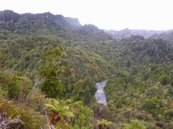
Then it was a short road walk to Owhango Reserve and the start of the 42nd traverse. This is a trail usually done by mountain bike and I had done this several years ago. From a trampers perspective it is just a gravel road through bush and I was not terribly excited by it, much more fun by bike. There was one stream crossing that I built a little bridge to let me jump across so I could keep my feet dry. I didn’t want them wet just before camping for the night. I then started looking for a campsite which wasn’t easy given how steep everything was. Eventually I found a nice site and settled in for the night.


Dinner was pumpkin soup with potato flakes for the main.
9 December 2014
Day 42. 42nd Traverse to start Tongariro Crossing.


It seemed to take longer than I expected to reach Waione River. I wanted to keep my feet dry a little longer so I took my shoes off and crossed. It was really cold. After drying my feet and putting my shoes back on I was off.
I saw a track to the left which I thought looked right on my map but there were no markers and there had been TA stickers at the main junctions so I thought there would be a mark of some kind to say which track to take.


I continued along the valley crossing two streams before checking my map again and realising i was way past where the track should be. I checked the more detailed map on my phone and saw I could take a secondary track to cut across and join the proper track.
I headed back the way I had come and met Dan Slattery from USA. I explained what had happened and what I was going to do and he decided to turn back as well. I got to the shortcut track but it was overgrown so I decided to head back to the right junction. Once there I scratched TA and an arrow in the ground so hopefully others don’t make the same mistake.
Now that we were on the right track we were away. I kept the pace easy and we made steady progress stopping for lunch along the way. After 10 km on the track there was a great marker for TA trail and 10 km sign. If only there was something like this at the junction where it is actually needed. The was another maker at the 11 km mark. The track went through some boggy patches and some steep slippery ups and downs but was generally ok.


We then arrived at a sealed road and took this past the Outdoor Pursuits Centre. At this stage it started raining harder than the light misty drizzle that had been on and off for the last two hours. With rain grear on we turned left onto a very overgrown track which meant I got even more soaked as I pushed through the bushes and trees. After 500m we reached the junction and I did a 1100 km photo before turning right onto a slightly less overgrown track.

I got smart and offered the lead to Dan so he could clear the wrist of the water of the overhanging trees – he he. At a junction we went left but this deadened so we went back and I saw a faded arrow pointing to the right. I made this more obvious and we moved on. We came to the Te Porere Redoubt which was in really good condition and impressive engineering. This is where Te Kootie made his last stand against the British in 1869.


Dan was a nice walking companion. There was occasional conversation but not constant chatter and when he was in front the pace was good. Also he seemed happy with my break schedule, not that I took many, just one snack stop and lunch.
It was then a 6 km road walk which seemed to take ages. I had to keep my pace easy to stop my niggles from reappearing and I told Dan to go ahead as he was faster than me. Finally we reached the Tongariro Crossing endpoint and within 30 minutes it was empty of people. We had dinner to which Dan generously donated some water to me as I didn’t have enough and expected there to be a tap at the car park. After dinner Dan decided to push on while I opted to camp under the waiting area shelter so I could keep my tent dry as I expected it to rain during the night. It is no camping in the car park but it is also no camping anywhere within 500 metres of a Great Walk which the crossing was. I figured I was having less impact putting my sleeping bag on a wood platform than pitching my tent.


Answer : Toi Toi Frond

10 December 2014
Day 43. Start Tongariro Crossing to Whakapapa.
As the track left the bushline there was a light drizzle but as I was sweating from the climb I opted not to put my jacket on. About 40 minutes later the rain started to get heavy and the wind was keeping me cooler now so I put my jacket and rain skirt on. The other walker passed me when I stopped and I quickly caught and passed him again.


The early birds were coming back down the mountain and had just gone to the Hut.
I reached Ketitahi Hut at 0815. This hut is closed for overnight stays. It was hit by rocks in the 2012 eruption and there are some big holes in the roof from the rocks, one directly over one of the bunks. I had a snack and then decided to put on my rain trousers for the first time this trip as expected it to get cold at the top of the mountain. I also put on my rain mitts.


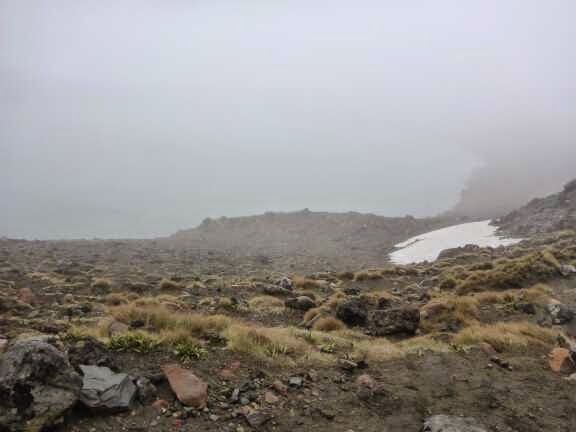
From the Hut the steady climb continued though the groomed gravel track was now a rocky path. It seemed really quick to get up to Blue Lake which I could just make out through the rain and mist. The wind was much stronger now driving the rain sideways. From the lake it is down into a crater, past the normally beautiful Emerald Lakes and then the long steep climb up loose gravel. I was having a little trouble with the wind blowing me around but the other walker, who i had caught up to again as he passed me at the hut, was bigger than me and didn’t seem to have an issue.


I had forgotten how long this steep bit was and combined with altitude was a bit puffed by the time I got to the top. I have done this walk and most of the other ones in this National Park as it was my playground when I was based in Waioiru Camp.
At the top the wind was much worse and I was using my poles to stop getting blown over. This was the first time I wished for a heavier pack to keep me grounded. The downhill was slippery on the loose gravel with the wind knocking me off balance I took my time and the other Walker gained some distance on me. It was then a flat walk across south crater in the mist.
Visibility was about 30 metres which was about the distance of the marker poles but the path was pretty clear. This is a popular walk which in peak season gets several hundred people a day on it. Today zero apart from us though there were 2 doing the Around the Mountain Circuit.

I was planning on doing Mt Tongariro and Mt Ngauruhoe (Mt Doom in Lord of the Rings films) however with the weather so crappy I gave it a miss. I have done both several times so no big disappointment.
From the crator it is a steep descent down Devils Staircase and this has changed beyond all recognition from when I did this last. Before it was a rough trail up through the rocks which was a real scramble. Now it is groomed gravel trail and stairs and was an easy descent. The track from the bottom to the Hut was also much improved with a lot of boardwalk and wide gravel tracks. The other Walker and I were travelling at the same speed now we were on the flats.

We made it to Mangatepopo Hut at 1120. I stripped off my raincoat but chose not to go inside the hut as I would have had to take off my shoes and I wasn’t planning on stopping for long. I quickly demolished my lunch being entertained by listening to the Hut Warden trying to explain to people about changeable weather conditions and danger of bad weather on the mountain. She seemed relieved to talk to a fellow Kiwi who understood. The other walker decided he had had enough and he continued to the car park to catch a shuttle to Whakapapa.
I left the hut just after 12 and was now very clearly not on a Great Walk judging by the track standard. The track had some good bits but was dominated by washouts. The soil is very soft and gets washed away leaving deep grooves for the trail to walk in which given the amount of rain were a little muddy. People tried to get above the track but this was still slippery. I had one slip that could have been bad without my pole holding me up long enough to get a foot under me as I slid down a 1.5 m bank. Unfortunately my poles sacrifice was not without cost and it now had a slight bend in it.

After that I made it the rest of the way incident free and by the time I reached Whakapapa at 1410 the rain had washed the mud away.

Originally I was intending to camp a few km past the Whakapapa Village but given the heavy rain I decided to be a wuss and checked into the Backpacker at Skotel. The receptionist was lovely and told me to go and have a shower and get into dry clothes before worrying about the check in.
Once I was warm and dry I finished check in and went back to my room to wash out my socks and hang everything up to dry. There was a great heater and I discovered the towel rail was heated, not what I expected in a Backpacker room.
I relaxed until dinner having decided as I was being a wuss I would go the whole way with a steak at the restaurant. Absolutely stuffed I went back to my warm room and tried not to think about heading back into the rain tomorrow. The rain was continuous and varied between heavy and really heavy. Nice to be listening to it from my cosy room and at least my stuff will dry tonight so I don’t have to put on wet shoes and socks which is the absolute worst thing about tramping, even though after 30 seconds they feel fine I still hate that first 30 seconds.
11 December 2014
Day 44. Whakapapa to National Park Village.
I started the day with a cooked breakfast of pancakes and some hash browns with some nice coffee and orange juice. I figured this should give me enough fuel to last the short 20 km day.
It was still raining so I geared up but the wet weather pants were relegated to the bottom of the pack again, not to make a reappearance until the Tararuas.
A very short walk down the hill and past the visitors Centre and I was on the Whakapapaiti Track.

The track started beautifully until it turned off for the shorter circuit to Silica Falls. From there it was still a lovely track but a lot of it was under a few cm of water. I was enjoying myself feeling like a kid again splashing through the puddles.


At the first Bridge I saw the water was running high and fast after all the rain recently. After seeing this I was concerned I would not get through the track and would be forced to turn back due to the high rivers but luckily all the big streams were bridged.


I had to cross a few small streams but they were not a challenge. I stopped at one to take a photo and the Walker from yesterday turned up. I figured we would be crossing paths throughout the day and thought I must ask his name next time i saw him but I never saw him again.

The track was mainly in the bush but occasionally came into the open at old slips, streams and mountain swamps which were all boardwalked. Despite how wet the track was I thought I was making good time but I only got to the track junction 15 minutes sooner than the DOC time.


At the junction I turned into the Mangahuia Track and this is where things got fun (read challenging for those who do not have a warped sense of what is fun). The trail for the next 5.5 km was effectively a stream and constantly under water from mid shoe to knee high. The first 2 km was in the open and this was largely narrower trails of water, some moving at a good rate on the downhills. There were some larger ponds to get through a well. It was funny to see a couple of small bridges considering what I was walking through. There wasn’t much mud on the trail, just water.


Then the track entered the bush and I thought the water would reduce but no. It became wider and there was more mud but this was usually under a cover of water. It was actually pretty setting the reflection of the trees on the water as I splashed through. The water was on average mid shin for these parts.
Just after entering the bush there was a steep downhill and I arrived at the Mangahuia Stream. This was running really fast and looked deep and there was no way I was going to be able to cross it. Even if I waited for the other walker it was still not safe to cross with two people. I realised I would have to turnaround and go back to Whakapapa and road walk to National Park Village.
Before heading back I thought I would just have a quick look upstream just in case there was a crossing point. The bush was thick but I bashed through looking at the river in a couple of places and none were any better. Then just as I was about to give up I plunged into the thickest part of the bush and came to the river edge where the river split in two to go around an island and the current was reduced here and there were more rocks. I was happy with the depth and current so decided to have a go at crossing. The first channel was only mid shin and not a worry. On the island I had a look at a couple of places to cross the second channel but there was a steep bank on the other side and it looked too deep. Slightly upstream was a nice get out point and it didn’t look to deep. Also the were a couple of big boulders I could use to protect from the flow so I decided to try crossing but was ready to back up if it got too deep or fast. I took my time making sure my poles were steady and one foot at a time firmly planted and it was actually easier than I thought it would be, apart from the shock of cold water at crotch level (mid thigh on a person of normal height).
Once across I then had to bush bash all the way back to the track but luckily I came across a goat track which made it a bit easier.


Relieved I didn’t have to turn back I was on my way again after taking off my rain skirt which was redundant after getting my shirts wet during the river crossing.
I continued to splash my way down the trail strangely really enjoying myself. There was one section of boardwalk which I can only assume was an experiment given the condition before and after it.


Near the end of the bush section there was a long section of boardwalk and the the vegetation changed to Manuka and afterabout 500 metres of wading down the track a gravel track started. It was actually clear of water for most of and this continued all the way to the Mangahuia Campsite surprisingly 15 minutes under the DOC time of 2 hours 45 minutes.

Here I made the most of a tap to was the mud and grit of my shoes and socks in preparation for the 6 km road walk to National Park Village. SH47 was very quiet and the few cars going past gave me heaps of room. After climbing a small hill the road turned a corner and National Park was in sight however it was still 3 km away.

I plodded along thinking I was doing about 4.5 km/hr but I reached National Park in 1 hour exactly which was 6 km/hr – must have been the thought of hot food. Also thankfully the rain stopped just as I started the road walk and I was dry by the time I reached the village.
I went straight to the cafe and had a lovely chicken and pineapple burger with chips and a cupaccino. I then headed to the 4 Square (small grocery store) to buy lunches fur the next 6 days.
Then it was a hundred meters and I was at the backpackers. I booked the female dorm (my tactic to reduce the chance of having a snorer) and I was a little concerned as it was a 10 person dorm but so far I am the only one in it.


I rang Gavin of Yeti Canoes and finalised the detail for the Wanganui River. I had left my name with him incase he had someone else wanting to do the river and he contacted me yesterday to tell me he had some people getting in at Taumaranui so I could meet up with at Whakahoro (conveniently on the exact day I wanted) and we could continue on to Wanganui together. He also arranged the campsite bookings with DOC for me. I was really happy with this arrangement and relieved to get this sorted. It was great service from Gavin at Yeti Tours (www.yetitours.co.nz, freephone 0800 322 388) to arrange this for me, especially thinking outside the box and not just looking at people doing the Whakahoro canoe put-in, none of the other companies had gotten back to me.
Today I decided to give my walking poles names (I am not having conversations with them yet so I am still sane – really I am). In the Army some people name their rifles because they are so important to their survival and I think the same about my poles. The right one is called Fred. In the old army ration packs that had tins there was a great little tool that was a tin opener and spoon and this was called a Fred. As my pole is also a camera tripod, selfie stick and tent pole out is multi use like a Fred. The other pole is called Brave Banana due to the slight bend incurred yesterday as it saved me from a bad fall, sacrificing it’s sleek straight lines.

Also my socks seem to be at their end of life. They just need to last to Palmerston North where I can get free replacement at Bivouac (Icebreaker lifetime guarantee)

12 December 2014
Day 45 National Park Village to just short of Whakahoro.
It was an entertaining evening taking about what we have been up to, gear, future plans and LOTR as Joey and Geoff are big fans. Hopefully of the plan works out they will now be joining me for the canoe down the Wanganui River which will be great. After such a long time not seeing any other TA walkers it is nice being around some.
Now back to this morning. I had a lazy start and once I had packed up I got into my rain gear and headed to the 4 Square/service station to get a healthy breakfast of chocolate milk and a steak and cheese pie. I then went back to the Backpacker to checkout and just after 0800 was on the road.
There was a short 1 km road walk through National Park Village to the start of Fishers Track. This track was a lovey gravel road through bush for the first 6.5 km. During this part there was a light rain and dense mist so I missed out on what I assume are nice views. There were heaps of footprints of deer on this track.
The gravel road then became a grass vehicle track for a couple of km then a narrower track for the last few km. I was below the mist now and the countryside was beautiful and rugged. Down below the track was a river winding through the valley and heaps of waterfalls. In this section there were heaps of wild goats which is not a good thing from a conservation perspective.


The track then joined a proper gravel road and finally the rain had stopped and I was able to take off my rain gear.
After 3.5 km I turned right into another road and followed that for 12.5 km. Along the way I stopped for lunch and a Grader went by which made the road easier to walk on for the rest of the road.


About 2 km from the end it turned into a sealed road and my body started complaining about this. For the first time my left knee was a little sore and my left shin (lower outside) as well. The knee pain went away after a break but I battled the shin pain the rest of the way. It would worsen if I tried to stride out so I had to drop my speed and take short steps then it would die down – frustrating.
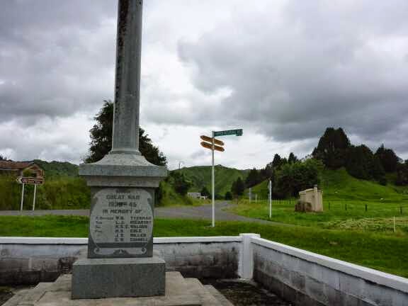
I was passed by a family on Mountain Bikes just before the
Junction. I caught up as the guy picking them up was explaining the history of the area and the war memorial there. He knew about TA and explained to the family who were impressed. They are doing Tongariro Crossing tomorrow and very excited. That was a nice break.
There were two signs at the junction. The road sign said 27 km to Whakahoro and the mountain bike trail sign said 24 so I will go with that one. The first 7 km was on tar seal and then thankfully it turned to gravel.


At around the 38 km mark my left shin got worse and was really sore. I stretched and massaged and really dropped my pace to try and make it improve but after a few km there was no improvement and I thought I would have to stop. I then loosened my laces and had a break and thankfully it improved and almost went away as long as I stayed slow so the challenge was still on. I decided to continue but was now not sure if I would make my 50 km target within time – it would be close.
The road started following the river for the last 8 km and it was a very scenic walk. I stopped to take a photo at the 1200 km mark and pushed on slowly. It was frustrating that I could not go at a decent pace as I was feeling good apart from the shin.


I made my target in 11 hours and 45 minutes and was pretty pleased.
I then started looking for a campsite and within 100 meters found a nice spot under some trees beside the road (on the road side of the fence so public land).


I was hungry so dinner went down quickly and I went to sleep fast to the annoying shreik of either a duck or Pukeko.
Visits: 1035
13 December 2014
Day 46. Near Whakahoro to Whakahoro.
I arrived at Whakahoro and went straight to the Blue Duck Cafe for a lovely Toasted Sandwich, smoothie and chocolate brownie.
I talked to one the farm workers and a few tourists then started sorting my photos and updating my blog. Someone who turned up said there were 4 trampers on the road and I wondered if it was the four guys I had met in National Park Village. I had soup for lunch and was just finishing up on my blog when the four guys turned up. It was Joey, Geoff, Julein and Romain (follow them on their blog http://geoffandjoey.tumblr.com). They had not been able to get a ride to the start of the Tongariro Crossing in time so they switched to plan b and started walking to Whakahoro to do the Wanganui River. After the river they would head back up and do the Tongariro Crossing. I was happy they had made it and would be doing the River Canoe with me, I was now in for a fun trip.
We just hung out for the rest of the afternoon at the cafe. The staff there were great and it was a very relaxing time. Maggie the cafe manager let the guys pitch their tents in the lawn for free which was great. She ask also packaged up some lasagna and salad for me to heat up at my lodge later.
In the early evening I headed to the lodge to see my room. I set my groundsheet up outside to dry and washed some clothes before eating dinner which was really good.
I headed back to the cafe to hand out with the guys until 2100 then back to the lodge. The other lodge occupants had turned up. They were the hunters from Taupo who were really friendly. They had been told what I was up to and wanted to ask some questions so I sat down and talked with them while they plied me with some fantastic port, chips, Venison stew, more port, chocolate and even more port. They were very entertaining and it was a fun evening. I went to bed just before midnight which for a hiker is very late.
14 December 2014
Day 47. Whakahoro to John Coult Hut.
It was a really relaxing day as the water was running fast and the kayaks were faster than the canoes so we did not need to paddle much. There were some bits of white water but they were all really tame.
It was really funny watching the four guys paddling along in their santa hats. When they saw anyone they would throw a bit of fruit and say merry Christmas.
We pulled over for lunch on a stone beach.
After that we just drifted down the river which was beautiful with bush on both sides.
There was a USA vs France water fight ongoing with water pistols and water balloons.
Overall it was an enjoyable day.
We reached our campsite at 1530 and after tieing our boats up carried all our stuff up to campsite. After pitching our tents we meet Angela and her boyfriend who offered beer or wine to all of us. We spent the rest of the day and evening at the picnic table talking, being shown magic tricks, playing cards and eating. The guys had gone shopping in Ohakune and given their food to the kayak company so they had lots of food and wine making for a good time. I felt a little bad not being able to contribute but in Wanganui I will be able to make it up by buying pizza or something.
As it started getting dark at around 2100 we went to bed.
15 December 2014
Day 48. John Coult Hut to Ngaporo Campsite.
We paddled gently for 18 km until arriving at Mangapurua landing. It was not an easy landing to try and get our of our boats but eventually they were tied up out of the way of the incoming jet boats. We then walked the 2.7 km to the Bridge to Nowhere with the four guys in Crocs and their Santa hats. I was impressed at how easily they walked in their Crocs. We didn’t spend much time at the Bridge as it was really a plain Bridge only made famous because they never managed to link up the road leaving a proper vehicle Bridge accessible only by waking or biking.
We did the balancing acts again to get back in the boats and only went 100 m before pulling in at the Mangapura shelter to have lunch. Having hiked by myself for most of the TA it is interesting seeing what other people are eating. They have an interesting combination of avocados, cheese and peanut butter on tortillas. They also eat a lot of tuna.
We then carried on with our relaxed pace. It is nice just floating along staring at the clouds and the bush or watching the birds. Physically it was easy as the kayaks are so much faster than the Canoes so I only had to paddle a few strokes and then rest a while before paddling again.
There were some entertaining interludes with water fights between Team USA and Team France. Fabian and I are happy watching from a safe distance.
If I felt bored I would just talk to one of the guys and if I felt like some time alone I either floated at the back or pushed in front a bit.
We decided to skip the campsite Fabian and I were at as the others did not have a booking and might have to pay the penalty price. Also this was a popular stop so there woud be heaps of people. We pushed on another 1 hour 45 and came to Ngaporo Campsite which was lovely and, unlike the other one, we could see the river which was nice. We set up our tents and ate dinner and talked.
There was a press up competition and I did well but I will not mention the results for great of embarrassing 3 of the men. Fabian did not participate (yes you can now do the maths). In their defence they did work harder paddling their Canoes than I did in my kayak. Once again the guys were generous with their no weight restriction food and shared their chips, red wine and tea.
We were observed by one cheeky rat who watched us for a while quite openly. We also were dinner for hundreds of Sandflys until covering up and using repellent.
As it stayed to get dark we headed to bed hoping our boats would be there in the morning as there was nothing to tie them to and it was hard to drag them high.
Tonight I go to sleep to the sound of the river and a nearby waterfall. As it is a warm night and does not look like raining I have left my tent doors tied up and can look up at the stars as I am laying here.
16 December 2014
Day 49. Ngaporo Campsite to near Koriniti Pa.
Today was more of the same stunning scenery, relaxed paddling and occasional conversation.
The Team France water pistol is broken so water fights are off. Instead they played with an inflatable ball that is coloured like a watermelon with their paddles and Geoff tried fishing off his canoe with no luck. We had lunch on a patch of stones and it was so hot 3 of us were perched under some Manuka for shade.
After Pipiriki we were off the Great Walk part of the river and had the water to ourselves with no more jet boats. The scenery slowly changed from primary bush to secondary (regrowth) bush to farmland and non native trees. It was still pretty scenery and the rapids became more fun. I actually had to think slightly about how to get through.
Just before 1600 we started looking fur a campsite and after a couple of attempts we find a nice spot at 1700. After checking gps I realised it was opposite Koriniti Pa which is listed in the trail notes as a place to stay but there was no sign on the water to say this and we were already set up so we stayed.
The Sandflys were really bad here and we were driven to our tents early to take shelter from them.
17 December 2014
Day 50. Koriniti Pa to TA km 1345.
Lunch was on a log on a stone beach but was not enjoyable as I was under concentrated attack by the Sandflys. They were there in numbers and focusing on my unprotected feet so I was glad to get back into the protection of my kayak.
Today was a nature show. The were more goats and today there were also cows and sheep, sometimes all right next to each other. We also had a small deer swim across the river in front of us and jump up a bank. Also there was another couple of deer, rabbits, geese and ducks.
As we went under a cable way we saw a horse in the basket so we waited and watched it cross. They went just up to the river edge then stopped to calm the horse down and stop the basket swinging so much. Then as they crossed over the river the horse was calm.
I started feeling tired just after 1500 so I drafted behind Joey and Geoff who were paddling strongly in the afternoon. Just as I was feeling better and went off to the side we stopped at our campsite which my favourite for the river. We were up a bank overlooking the river and under a really interesting old tree. We sat around in its branches drinking wine then eating dinner. After dinner Joey played some music.
A farmer passed on his tractor on the track across the river and let us know our boats were upside down in the water. Joey checked and we discovered that this part off the river is tidal and though we dragged the boats well out of the water they were now floating. Luckily we had all tied them to branches so they hadn’t floated away. Both my hatches were full of water which meant my shoes and pack were now wet. We emptied the boats out and moved then higher though it was now high tide.
After that that we went to bed.
18 December 2014
Day 51. TA km 1345 to Wanganui.
After getting changed back into my walking shorts I started walking by myself as I wanted to take it really easy after being in a kayak for the last 5 days and I was sure the guys would be walking much faster than I wanted.
My knees were slightly sore and my hamstrings tight to start with but after a couple of km every thing loosened up.
I stopped at a Dairy for some chips and an ice cream to eat as I was walking.
At 1250 I arrived at Bramar House YHA but reception did not open until 1300 so I checked my emails while I waited. Just before 1 I heard horns tooting and looked up to see the guys walking past. They had their santa hats on and were getting a good reaction from the cars. I caught up to say thanks for the fun trip and to see if pizzas tonight would work.
I went back to Bramar House but they were full so I went another 300 metres down the road to Tamara Backpackers who had room. I got a female share 3 person room. Tamara Backpacker was great. It was clean, tidy, good condition and the manager was really friendly and full of information.
On his recommendation I went for kebabs which were great. Back at the backpackers I had a shower and put my smelly things into the wash. I then started sorting my photos and relaxed. I ordered in pizza and ate the whole large pizza in one go with room for more.
In the evening I talked with Fabian who was staying at the same place. Unfortunately I missed catching up with the other guys as they only got out of the Hobit movie late.
I went to sleep at 2230.
19 December 2014
Day 52. Wanganui to Santoft Forest.
I was on the road at 0830. Today started with a couple of km out of Wanganui then 20 km on SH3, a very busy road. After an hour I had just sat down for a rest when a car pulled up to the intersection and the people indicated that they wanted to talk. It turns out they are doing TA themselves. They had done everything south of Wanganui and some bits in the north
They intended to keep doing bits and finish. They had some good stories of some of their trail adventures and I enjoyed the chat.
Nearly 30 minutes later I continued on my way. One funny sight was seeing a horse scratching itself on the support wire for a power pole and seeing the whole pole shaking and the wires all the way to the next pole.
The road had decent bike lane for most of it but there were two bits that were more narrow and I had to walk on the rough grass to keep out of the way of the incoming traffic.
There was one small detour through a little town called Whangaehu and I was hoping there might be a shop to get a cold drink as I was roasting. The was a building labeled General Store established 1946 but unfortunately it was not a store anymore.
At Turakina I turned right and had another 8.5 more km to walk to get to the beach at Koitiata. Just as I was entering the town a car pulled over and started reversing back to me, though very badly and I was getting ready to jump out of the way when it stopped. The lady asked if I was doing the trail and then told me she worried about women doing it on their own, especially with the druggies who are growing marijuana in the forest along the beach. I explained that I had only had positive experiences so far and liked the independence. She invited me back to her house to fill up my water bottles which I accepted. When I arrived she had water ready and some iced water to drink which was fantastic.
I then walked to the beach and followed this for the next 8 km,
stopping for the 1400 km photo. It was an interesting beach, complete with a seal. It is black sand and there is heaps of driftwood and dunes. I was lucky with the tide which was coming in but still left enough room to walk on firm sand for 7 km and the last km was softer buy still not too bad. Also the one stream we had to cross was conveniently bridged with driftwood.
The marker off the beach was very hard to see , especially when I didn’t know what I would be looking for. Luckily my time estimate from Koitiata Stream to the turnoff was spot on so I was actively looking for some mark.
From the beach the track went over the dunes and dropped into a tunnel of trees before coming out onto a gravel road. I followed this for a km then at up camp in the pine trees. The best thing- NO SANDFLYS
4 comments:
20 December 2014
Day 53. Santoft Forest to Fielding.
I was on my way at 0800 down a gravel road in the forest for 3.5 km. Then due to logging operations on the trail I started the detour which was all sealed road.
It was really hot with the sun out with force and no breeze or shade. I was really feeling the effects and drank most of my water very quickly. I passed a guy and he made a comment which I replied to then he asked the normal “where have you come from, where are you going” questions. He let me know it was only 6 km to Bulls and I said I was glad so I could buy a cold drink. He immediately said I could have a cold drink at his house. I didn’t want to put him to any trouble but said it would be great if I could refill my water bottles. So this was the start of some amazing hospitality from Mike and Jean Robinson.
Mike led me around to his house where I met his wife Jean. They offered me tea and I asked for just a water, not wanting to be a bother. Mike filled my water bottles and Jean offered to make some lunch. When I hesitated she asked if I had any timing to meet and when I said no she said I was to stay for lunch and I didn’t need asking again as the hiker hunger overrode politeness. As i was now staying for a little while they put my water bottles in the freezer so they would be cold when I left. The three of us talked as she made since sandwiches and this time I said yes to a cup of tea. The sandwiches were delicious and these were followed by a muslea bar, then oranges, apples and bananas and some fantastic fudge that I would pay a lot of money for in a shop as it was exactly how I like my fudge. Along with this fantastic feast was interesting conversation. When it was time to leave they offered me a shower which while tempting I declined knowing I would be sweating as soon as I started walking again. Jean then gave me a handful of fruit leather sticks which are a great idea to try to stave off the fruit craving I have.
Jean and Mike were amazing. They were so giving and generous to a random smelly tramper. Nothing seemed like a bother and they genuinely seemed to want to make life better for a complete stranger. I really enjoyed my time with them. I have decided to save one of the fruit leather strips to Christmas Day when I will think about them and the other amazing people I have met on this adventure.
I left Mike and Jean’s house nearly 2 hours late feeling a lot better than I arrived and the rest of the road to Bulls went quickly despite the heat.
I got a thick shake from McDonald’s and continued out of town on SH1, across the Bridge over the Rangitikei River and onto quiet backroads. The sun was now covered by clouds buit it was still humid and hot . After about 4 km it started raining so I put on my rain gear but the rain stopped and I was over heating so I took it all back off 5 minutes later. It then continued to rain on and off until 1730 when it started raining continuously and harder so my rain gear went back on and stayed for the next 2.5 hours. Talk about contrasts in weather today. Just as I was approaching Fielding around 1930 it stopped raining. I then started looking fit a campsite and found a stealth campsite under a tree in Kowhai Park (there was no sign saying no camping but I kept a low profile anyway), near the avaries which makes for some interesting sounds to sleep to. I think I can hear a Kea which I will have to check out tomorrow morning.
As I write this my tent is being bombarded by two very large and noisy insects demanding entry into my tent. I had the same last night and I think they are Huhu Beetles.
21 December 2014
Day 54. Fielding to Palmerston North.
In Bunntthorpe I stopped for a cold drink and the lady at the dairy was curious about my walk. I left sad because she said she would love to go camping but hey husband would not let her and demanded she was always there to look after him. He sounded very controlling and would not let her go away with her friends for more than a couple of hours.
At another 1.5 km I had the excitement of waking on grass on a paper road for a whole 1.5 km. I have recently heard that the Manawatu section of the Te Araroa Trust is working hard to find a way of the roads in this area which would be great as it is a lot of road without the breaks into different terrain that we have had elsewhere.
It was then 4.5 km more roads passing through the outskirts of Palmerston North before getting onto the river trail for the last 6 km to the Fitzherbert Bridge. Not long onto the river trail the rain started and continued until I reached the Bridge then it was Blue sky with no sign it had just been raining. This weather is crazy.
From the Bridge I walked into town meeting two TA people on their way out of town.
I checked into the Pepper Tree Backpackers, went shopping then relaxed for the afternoon.
22 December 2015
Day 55. Palmerston North zero day.
Today 0 km.
I had a good sleep in then had breakfast in bed and read for a while. At 1130 I headed out with the first priority being my resupply parcel from the Post Office. I then headed to Bivouac to pick up my walking pole section to replace the one that I bent. I sent an email to the shop before the river trip and when I got to Wanganui they emailed me to let me know it had arrived. I also swapped my Icebreaker socks for free again thanks to the lifetime warranty. The staff were really friendly and interested in the trail. The manager took photos of my Solomon Shoes to show the manufacturer where they were consistently blowing out for every TA tramper who has them. I was not impressed with the durability of these shoes. Day 3 the inner soles became unwearable and the mesh started ripping at 300 km with open holes in them by 500 km.
Unfortunately Bivouac didn’t have anything else I liked so I went to several shops to try trail runners but they either didn’t fit or were too flimsy. I took a break for lunch and saw Romain (from river trip) with another TA hiker I hadn’t met before called Jack. Then Joey and Julien turned up so we did a catchup. The guys had hired a car in Wanganui, driven up to Tongariro and done the crossing in good weather, driven back to Wanganui and then walked the trail to Bulls. From there the 3 hitched to Palmerston North to get essential things done while Geoff walked the rest of the way.
After lunch I went back to my shoe quest without luck so I decided to go back to Bivouac and get the Inov8 shoes I started with. I figure there is not as much road walking now so I should be good in them again.
I then hung out in a cafe filling up with smoothie and coffee before heading back to the Backpacker, stopping at Subway for a sandwich for diner. I struggled with the Internet so gave up updating my blog and just relaxed. Fabian turned up so we caught up with what we had been up to. I then read, packed up and went to sleep.
Night 54, 55
2 comments:
Awesome job! Keep on having fun! Wishing you continued success and enjoyment in your adventure!
Justin (trail name ‘The Proctologist’) and Soren
La Conner, WA, U.S.A
justnwill@yahoo.com
360-420-8556
23 December 2015
Day 56. Palmerston North to Burtons Track.
Today 29 km trail + 2.5 non trail. Total 1499 km (+12). 7 hours 30 minutes (1030-1800).
I made the most of the great shower before finishing packing and leaving at 0730. I stopped at McDonald’s for breakfast and stayed there an hour and a half to update my blog. I then went to Countdown supermarket but they didn’t have everything I wanted so I also went to Pak n save. Now fully loaded I walked back to the Fitzherbert Bridge, via a service station for an ice cream.
I was back on the trail at 1030. once across the Bridge the trail headed to the university (where I got my bachelors and masters). It then followed the Turitea Walkway for 3 km. This was a nice easy trail through bush, forest and farmland.
Fitzherbert Bridge
Turitea Walkway
Great rubbish bin with Palmerston North theme
Turitea Walkway
There was then 2.5 km road walking before turning into a Green Corridor which was a lovely grass track beside, and over (3 times) a steam. I liked this trail but I imagine many people road walk around it because they don’t want to get wet feet which is a shame as it is a nice track.
This is what a shorn Alpaca looks like – very funny (on left)
The first of the stream crossings
Green corridor
Third Stream crossing
Very cute Alpaca
Final bit of Green Corridor
Next was a short sealed road which turned to gravel road and then a single track gravel path which is popular with mountain bikers. This was in bush for 2.5 km before coming into the open just before linking back to a gravel road.
It was then sealed and gravel road walking for 9.5 km to the end of Kahuterawa Rd. The last few km were pretty as we followed the stream. Unfortunately during this section I had christmas carols stuck in my head. It was only two of them and everytime I was not consciously thinking of something they would sneak back to the front of my mind. The two that were stuck were ‘Santas Coming to Town’ and ‘Rudolf the Red Nosed Raindeer’. Unfortunately I only know some of the words so it got a bit repetitive and I started coming up with my own words.
View during road walk
From the end of the road the trail went on an old logging road which is now a popular mountain bike track. I had actually been on this track for the Army MTB champs several years ago, on a borrowed mountain bike that the gears were slipping and the brakes the old V Brakes which are hard to get used to after having used disc brakes for a while. I think this was a set up from the Linton team to stop my Southern Team taking out the competition. There were a few steams but I was able to rock hop all of them keeping my feet dry At the last one I filled my water bottles ready for camping.
Start of mountain bike track
Track up to Scotts Road
More track
Weta on the trail
At the end of the track I followed Scotts Road for nearly two km then turned left and in 50 meters was at the start of Burtons Track.
Very impressive sign at Scotts Road junction
Bridge crossing into forest
I was a little unsure here as the notes say daylight access only but I was not sure which part of the track this restriction applied to. The first part was forestry, then DOC land, then private farmland and then DOC again. I figured the restriction wouldn’t apply to the DOC land so I figured I would camp once across the boundary.
Unfortunately the forest had been logged and there were only baby pine trees so there was no shade. The gravel road followed the stream then headed up a small hill. Once back down I spotted 4 familiar tents at the junction and it was Team USA and France. I stopped to talk and got my first, and likely only, Christmas present – a candy cane.
Forest Road
I continued on a few km and set up camp near the boundary, but I couldn’t resist my favourite camping location under pine trees so I was not quite across the boundary. It was the magic toadstool that weakened my resolve. Who could resist camping next to this beautiful toadstool.
Beautiful Toadstool
Night 56
I stopped walking at 1800 which seemed really early given my late finishes but is back to my former Wanganui River routine. With my late start it was a short day which is probably a good idea with new shoes though they were great. I noticed how much lighter they are. I had no trouble with my shin today and was able to walk full speed which I think is because the shoes are lighter which means my tendon is not having to lift as much and is not under strain. I guess I will see.
24 December 2015
Day 57. Burtons Track to Makahika Outdoor Centre.
Today 29.4 km. Total 1528.4 km (+12). 10 hours (0800-1800).
Once again it took longer than normal to pack up and I was on my way at 0800. I knew it was only 1 km to the 1500 km mark so when I saw some Toi Toi fronds recently cut down on the track I gathered several and carried them up the hill to make sure I had something to mark the distance. At the junction and start of Burtons Track I marked 1500 km and took a photo. It took a couple of goes to get the timing right for a jumping shot with the camera self timer but I ended up with a suitable shot to celebrate the half way point of the trail.
1500 km HALF WAY!
View from the start of Burtons Track
I was pretty chuffed to be at this milestone and it almost seemed to come too soon. For some reason I had it in my mind that Wellington was the half way point. I sat for a while absorbing my achievement and thinking about how the journey was continually exceeding my expectations and how much I was enjoying myself.
As I was up high I had internet connection so I posted my half way photo to Facebook and I received a message from am old army friend offering accommodation in Waikanae which was great.
It was nice sitting be sun looking at the view but I forced myself to get moving at 0840. Burtons track was a nice track. It started dropping down to a river at a nice gradient to allow fast travel without being too steep. The track was in good condition and was clearly marked.
After 30 minutes Geoff came thundering past at a very fast pace. 10 minutes later the rest of the guys flew past. I walk at a faster than average pace through the bush but these guys made me feel like a granny with their impressive speed.
Burtons Track
Burtons Track
Burtons Track
10 minutes later I was surprised to see the guys at the river but when I saw Geoff soaking wet I realised why. He had tried to cross the Tokamaru River using a log and slipped ending up fully immersed, pack and all. Luckily he didn’t hurt anything except his pride. It was especially funny given the amount of river crossings throughout the day where there was no way to avoid getting wet feet.
I kept going and shortly after the guys came storming past again. 10 minutes later I caught up as they must have taken a break and then they disappeared into the distance leaving me in their dust.
The track continued along the river crossing numerous streams and the river a couple of times.
The guys at Tokamaru
Crossing Tokamaru River (thanks to Romain for taking photo)
And 10 minutes later crossing it again
After a bit in the open there was an information board at the site of Burtons old house. The track is named after the guy who built it to access his farm. He also built a swingbridge across the river and one day he fell from the Bridge and broke his leg. He crawled back to his hut, fed his dogs and then crawled nearly 4 km in 12 hours to get help. Unfortunately he died in hospital from his injuries.
From this point the trail was on the track he had built by hand. Burton was not afraid of hard work! It followed the river undulating in and out of small streams through the bush and then baby pines.
Some open bits
Nice big orange triangle
The track Burton made
Burtons Track
Interesting roots
View once through the bush
It was then just over 5 km of gravel roads, coincidentally passing some land I had considered buying a couple of years ago and past the reservoir. I had lunch on the dam enjoying the views.
Lunch on the dam
The Reservoir
Interesting flower if you could call it that
The next track, the Mangahao-Makahika Track, was great. It was well maintained though did have frequent minor boggy bits. It started with a climb and then undulated for a while before climbing onto a ridge and then followed the ridge line for a while. After a viewpoint it dropped quickly to an old tramline that it roughly followed crossing, and walking in, the Makahika Stream continuously for nearly an hour. I was really happy to be back wearing the Inov8 shoes as they drain so quickly after stream crossings and have excellent grip in the mud.
Lovely track
Clear and fast
Goblin trees
View from Archers Viewpoint
The trail through the stream
Into the farmland
The final river crossing
And nearly at the road
There was some lovely campsites near the end under Punga Trees which I did consider camping at but I decided to push on knowing there was potentially some Trail Angels near the end of the track. Being Christmas Eve there was a strong likelihood they were not home or had family around but it was worth the risk. If I couldn’t stay with them I would just camp at the next trail car park.
The track then emerged from the bush into farmland for a couple of km and then it was 1.5 km to the Makahika Outdoor Pursuits Centre. As I approached I saw there were several cars and it looked like they did have visitors. I figured I would just ask to fill my water bottles and move on. As I got to the gate I saw a blackboard welcoming TA trampers for Christmas which was a great sight.
I walked to the house and was warmly welcomed as if I was an expected guest by Sally and John. I was told dinner was at 1830, my room was in the lodge below the house and to use the shower, washing machine and help myself to food. Sally and John had welcomed 10 TA trampers for Christmas with amazing hospitality. They had been told I was coming by the guys. It was like a little reunion as I came down the hill to the lodge. Joey, Geoff, Julein and Romain (“The guys”/”Team USA and France”) I was expecting. Also there was Jack Saari (famous for wearing short pink shorts on trail), Ange and Phil (“The Brits” I walked with through the rain in Pureroa Forest) and Arne and Lena (the tall SOBO Germans who were going NOBO through Pureroa Forest when I met them). Apparently Fabian was invited to stay but had made the decision to continue on and camp at the trail car park.
I had a shower but didn’t bother doing washing as I was leaving in the morning. At 1830 we walked up to the house and met Sally and John’s family. I am not sure what they thought of all these scruffy trampers crashing their Christmas Eve Dinner but they were all very friendly.
We sat around talking and drinking (Sally gave me a lovely white wine). Then dinner was ready and after the family we went through, oldies first which was the Brits and me. I didn’t mind being called old when it meant being first in for food. Dinner was a Duck Breast perfectly cooked, a green salad with capsicum, avocado, cucumber and raspberries with a balsamic vinegar dressing and ciabatti bread – fantastic!
Though I had intended to keep walking tomorrow Sally was forcefully convincing to make me stay using underhand tactics like listing all the food that would be served with Christmas lunch. My resolve quickly weakened and then collapsed in the force of good company and great food versus alone in a hut eating a dehydrated meal.
We continued talking until it got dark then the younger ones went back down and built a fire. All us oldies stayed at the house talking with Sally and John and their parents. I then headed down to the fire and at 2330 we went into the lodge and a few of us saw in Christmas at midnight before going to sleep.
Relaxing before dinner
Campfire
Night 57
1 comment:
25 December 2015
Day 58. Makahika Outdoor Centre Christmas Day Zero .
John had put up a shade for us and Sally had done a great job to present a beautiful table. We all checked out the santa and reindeer footprints which Sally had laid last night.
Sally and John’s family went through for lunch and then the trampers were let loose. The good was amazing with little touches that added that little extra that turns good food to great food. Thete was enough left for seconds which gives a good indication of how much food was prepared.
After lunch we played Petonque/boules. After a fierce competition I was soundly last – sorry to my partner. Team USA conquered the French, Germans and Commonwealth to be crowned champions.
We then headed back down to the bunkrooms and the others played Touch Rugby, volleyball and soccer. I resisted joining in knowing my inability to take it easy and consequential liklihood of injuring myself.
After this we just chatted for a while and then headed to bed.
1 comment:
26 December 2014
Day 59. Makahika Outdoor Centre to Nichols Hut.
I was passed by Sally and John who were dropping Arne and Lena off at the track start. They were just leaving as I arrived. I filled in the Intentions Book and went through the shoe scrub and disinfect routine.
I was on my way just after 0830 and got to the Waiopehu Hut 2 hours 55 minutes later. The track was in good condition with only a few drying boggy patches near the top. It was a steady climb that would have a steep bit followed by an easy bit which let me catch my breath. On the way I passed Arne and Lena as they were talking to another tramper.
I love the big climbs like this as you can see the vegetation change at different altitudes.
I had a 15 minute break and refilled my water bottles before continuing to the next Hut. Just past the hut was the turnoff to the toilet and on the ground at this junction was a large Weta. I did my good deed for the day by moving the Weta off the track to save the Weta from being stood on and to stop it giving a fright to other trampers – potentially messy when they are on the way to the toilet.
I reached Te Matawai Hut in 2 hours 15 minutes (hut to hut). Just past From this hut it was a big climb up to Mt Pukematawai. Parts of this climb were a little exposed and required hands on rocks and roots to pull myself up. Warning to anyone scared of heights you will get an adrenalin hit. The junction near the top was only 50 metres from the summit so I climbed the extra bit to bag the peak – giving a yell of exhilaration as I summited which I later found out was heard by other people.
It had been overcast most of the morning but was starting to clear and from the top I had moments of great views in between the clouds blowing past.
Once back down at the junction it was a descent that was easier than the way up and I followed the open tops for a while before descending to the bush to Dracophyllum Hut (3 hours 20 minutes from Te Matawai Hut). This is a cute 2 bunk hut which was occupied by the rare Kiwi TA tramper. There were two guys older than me called Fred and Nev. They were great to chat with and they gave me tea and Gingernut Biscuits. This meant I stayed longer than I intended (35 minutes).
It was then more bush travel through what I call goblin forest due to the twisty trees and thick moss. There were two brief climbs above the bush line and the descent from the second was steep, exposed and slippery due to loose rock.
I arrived at the hut as the sun was dropping meaning beautiful colours on the mountains and clouds. I arrived at Nichols Hut 2 hours 15 after leaving the last hut at 2045. This was a long day and a tough physical day as I had hoped. I was pleased with how I went and could have kept going if needed.
Nichols Hut is a 6 bunk hut just down from a ridge overlooking a beautiful valley. I was very happy to have the place to myself as I imagined other people would have been a bit grumpy at me turning up so late.
I cooked dinner and crashed.